Way back in 1970 the Tullamarine Freeway was officially opened. Running 18 kilometres between Melbourne Airport and the edge of the inner suburbs at Flemington Bridge, this is what it looked like a few months before opening.
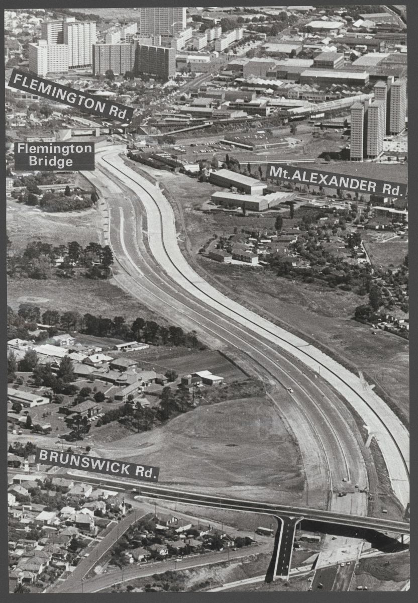
The freeway itself had two lanes in each direction, with Moonee Ponds Creek running along the western side in a concrete channel.
In the 1990s as part of the CityLink project the freeway was widened to four lanes in each direction and extended south to the West Gate Freeway – resulting in this current view from Google Earth.

In addition, the former Royal Park Psychiatric Hospital has since been covered with apartments as the Athletes Village for the 2006 Commonwealth Games.
Footnote
And now starts another expansion of the freeway – the CityLink Tulla Widening project.

The inner section of the Tullamarine Freeway from Strathmore in was built by the MMBW, when it had responsibility for building inner urban ‘freeways’ with the Country Roads Board responsible for outer metropolitan ‘By Pass Roads’; the South Eastern Freeway from Toorak Road to Punt Road was another MMBW job, as well as the Queens Way underpass at the St Kilda Junction and the Kings Way Viaduct
THE MMBW sections had their own distinctive standards compared to CRB for bridge railing, sign gantries and street lighting – notably the low pressure sodium tubes that lit up in an amber colour for the inner section of the Tullamarine and South Eastern
http://mrv.ozroads.com.au/freeway_routes/F81N/pics/70-2890.jpg
http://mrv.ozroads.com.au/freeway_routes/F80/pics/76_03006_07.jpg
Both were built in waterways to get the land with minimal acquisition and in the case of Moonee Ponds Creek it was both straightened and channelised – it used to wind around between Brunswick Road and Mt Alexander Road, as well as behind Moonee Valley Racecourse which lost its chute…
http://melwayed1.melway.com.au/029.jpg
The major property acquisitions were around Moreland Road – Coonans Road which was realigned, as well had between Pascoe Vale Road and Napier Street where Hood Street and the houses either side made way for the freeway. At the city end Flemington (Upfield line) bridge was extended to allow for the extra lanes feeding in on the northern side
The overpasses from Essendon Airport in were initially planned for 4/5 lanes each way with the initial 2-2 lanes built together either under one side or in the middle as at Brunswick Road above. They will have maxed out with the 5th lane widening and even there it being a squeeze under the Moreland Road overpass inbound.
https://www.google.com.au/maps/@-37.7514685,144.9354236,3a,75y,151.99h,86.27t/data=!3m7!1e1!3m5!1sqq25UtSZqKJmb6pCLESxKw!2e0!6s%2F%2Fgeo1.ggpht.com%2Fcbk%3Fpanoid%3Dqq25UtSZqKJmb6pCLESxKw%26output%3Dthumbnail%26cb_client%3Dmaps_sv.tactile.gps%26thumb%3D2%26w%3D203%26h%3D100%26yaw%3D45.668713%26pitch%3D0!7i13312!8i6656
The split between the CRB and the MMBW when building freeways was an interesting period – it remained in place until the shakeup that was the Transport Act 1983.
With provision of wide overpasses for future widening was interesting – I’m struggling to think of other Melbourne examples.
[…] years that followed saw a period of massive growth at Melbourne Airport, and the construction of CityLink at the Melbourne […]