For a number of years I have owned a GPS data logger: my main use for it is tracking where I have travelled when I am chasing trains.
They are a pretty basic device: you turn it on, it starts recording your current location (“waypoints”) to the internal memory at set intervals, then you get home and download the data to your computer. From the logs you can view the path you took overlaid on a map, as well as graphs of the speed travelled at, the altitude reached, and so on. With the data geotagging is also possible, allowing you to save the location where you took a photo into the image metadata.
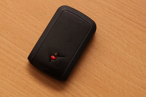
The particular gadget I have is a “Qstarz GPS Travel Recorder: BT-Q1000 Platinum” – it dates back to 2008, with Qstarz having released a number of updated devices since.
You can find a review of the device here, as well as a more detailed review of the previous model. I paid about $150 AUD for it from a Hong Kong based eBay seller.
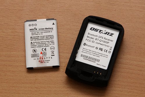
The BT-Q1000 is a standalone data logger, with a USB interface for downloading data, as well as a Bluetooth connection to supply GPS data to other devices such as mobile phones. It has one switch on the side to turn it on, with an orange lamp blinking once a GPS signal has been locked onto. A removable battery attaches to the bottom, it is a bog standard Nokia mobile phone battery in case you ever need to buy a replacement. The battery easily lasts an entire day of logging, with recharging occurring via the USB connection.
There are a few configuration options for the logger: the most important is the time between log recordings. It can be configured from 1 second upwards, with more frequent samples giving a higher measurement resolution, but will result in a shorter logging period, due to the limited space in the onboard memory.
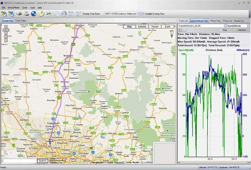
The resulting log in the included software is in the screen shot below. The main window shows the logged GPS track marked onto a Google Map, with a graph to the side showing speed and altitude reached during the journey. Hovering over the track displays the time logged at a given location, as well as the altitude and speed.
A few short thoughts about this data logger:
- It seems to suffer from a lot of ‘wandering’ in the tracks when standing in one place for a long period.
- Logs also go haywire when the GPS signal is lost, producing way points for locations you never passed through.
- Keeping a lock on a signal is difficult between tall buildings,again resulting in inaccurate tracks.
- I always seem to lose it, because it is so small! (about 1/2 the size of a mobile phone)
In addition, the included software to download the logs has a fair bit of “character” when using it. Some of the more irritating bugs include:
- It requires a product key to install, which is frustrating if you need to install the software on a laptop when you are on a holiday – this happened to me, and required a phone call to someone at home so they could fish around for it.
- Adding geotagging data to an image rewrites the included EXIF orientation data on photos.
- When tagging images it also recompresses the JPEG image data. (a degradation in image quality, which is BAD, BAD, BAD!)
- When matching photos to locations on the log, syncing time zones between the logs and your photos is an extreme pain, and attempts to fix it result in the EXIF time taken data being altered.
- Sometimes it locks up randomly, needing you to quit and open it again.
My unit came with a CD with version 4 of the software, since then version 5 has been released – you can download the more recent version of the software from the Qstarz website – you want the file “Travel Recorder V5.1 for XP / Vista”.
The new version enables exporting logs in different formats, and the correction of GPS drift. For what we are about to do, these features are rather useful, but they don’t fix the brokenness of the geotagging functionality.
In all, my data logger is one of my more useful toys. I only started geotagging photos during my recent trip to Hong Kong: my experiences with syncing location data with photos will be in a follow up post.

[…] A few days ago I posted an entry about my GPS data logger, a “Qstarz GPS Travel Recorder: BT-Q1000 Platinum”. I mentioned the ability to geotag […]
The wandering is a part of the GPS system as is loosing signal under things and in dense forest.
Thanks for that – I’m assuming the better quality GPS receivers have more sensitive antennas, allowing them to stay locked onto the signal better, when cheaper receivers just drop out.
The problem has as much to do with multi-path noise as with antenna sensitivity per se. I’ve done a lot of tests with GPS devices just sitting in one place for hours, and you will get a circle of noisy positions within about 5 metres, and then also curious excursions where the GPS device seems to wander away, up to 100 metres away, and then comes back.
The ‘excursions’ you describe where the track wanders away then returns are something I see quite often – the ‘correction of GPS drift’ feature in the Travel Recorder seems to fix it for me.
Another odd inaccuracy I found during my recent holiday was a consistent skew in the tracks recorded while I was travelling onboard a particular train – it was a one off occurance. When I looked at the track afterwards, the line followed the railway line perfectly, but just a few metres south. I’m going to assume some kind of signal reflection caused by the train resulted in the location being skewed for the entire trip.
[…] plotted the route I took through the Chernobyl Exclusion Zone using my GPS data logger – and here is the resulting […]
[…] the entire journey I had my GPS datalogger running – the resulting track can be found […]
Try saving the track as a GPX file and do your photo geotagging using an awesome program called Geosetter.
I use a Photomate 887 lite GPS. Only about $50 on eBay.
I discovered Geosetter some time ago, and it is good as you suggest! In the case of my datalogger, I needed to install version 5 of their software to export the track data in the GPX format, which Geosetter uses:
http://wongm.com/2011/03/geotagging-photos/
[…] the entire journey I had my GPS datalogger running – the resulting track can be found […]
[…] my 2012 trip to Europe I managed to break my GPS data logger, leaving me with no way to geotag my photos. Ordering a new data logger online and getting it […]