If you spend any time driving around the western suburbs of Melbourne, getting stuck in traffic along the Western Ring Road is an ordeal that will be very familiar to you. Viewed on a map the freeway looks just like the name suggests, a ring around the middle suburbs of Melbourne, except for a major kink to the west around Ardeer. So why does the freeway take such a sudden turn in that area?
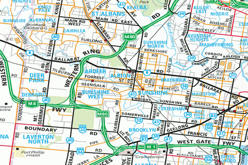
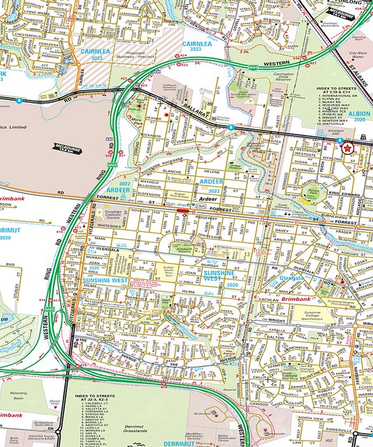
A closer look at the Melways shows that a direct alignment through the suburbs of Ardeer and Sunshine West is possible: an electrical transmission line cuts right through the middle of the suburb, with a linear park making use of the otherwise idle land.
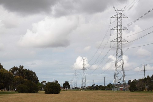
Down at ground level the space for a freeway is still there: this is looking south from Glengala Road.
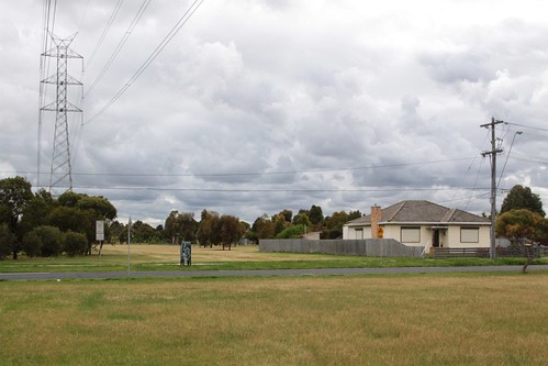
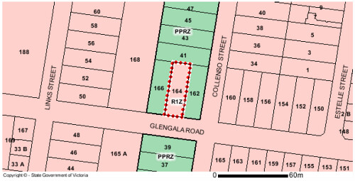
Turning to the north, only a single house blocks the open alignment: 164 Glengala Road, Sunshine West.
A check of the Land Victoria maps shows that this house has a conventional Residential 1 Zone (R1Z) applied to it, with the rest of the open reserve coming under the Public Park and Recreation Zone (PPRZ).
So with all this wide open space, why wasn’t the Western Ring Road built straight down the middle? To answer that question, I dug through my collection of old Melbourne street directories – as well as showing how much the city has grown, they often depict freeway proposals that never get built.
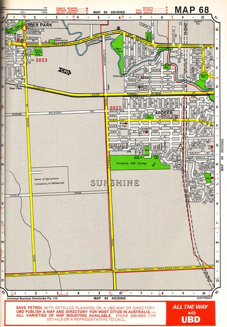
I hit paydirt in Edition 26 of the UBD directory, dated 1983, with map 68 showing a big dotted line running through the middle of Sunshine West and Ardeer.
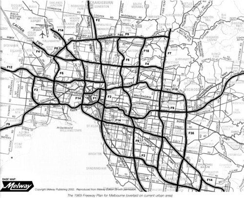
Digging back further to the 1969 Melbourne Transportation Plan, the alignment of the Western Ring Road was also visible, as part of the proposed F3 and F5 freeways.
So when was the alignment through the middle of the suburbia abandoned, replaced by a longer route through empty paddocks?
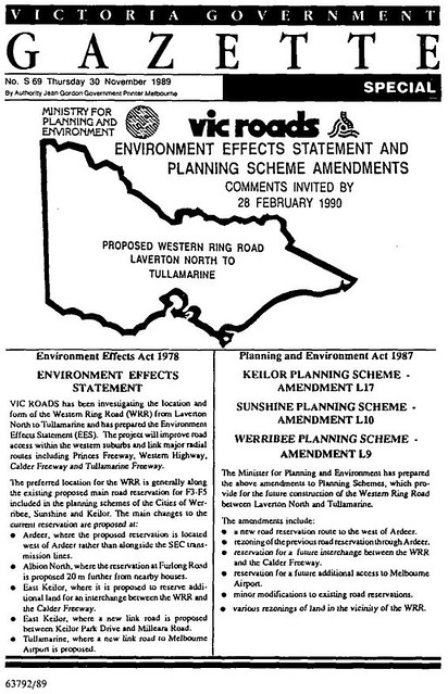
I found a lead in the 30 November 1989 edition of the Government Gazette, which introduced the Environmental Effects Statement approval process for the Western Ring Road. It detailed how the proposed freeway was to follow the existing F3 and F5 reservations already included in the planning schemes of the Cities of Werribee, Sunshine and Keilor – but not through Ardeer.
While the 1988/89 annual report for the Road Construction Authority gave some further context.
A planning investigation to prepare an Environmental Effects Statement for the Sunshine Keilor section of the Western Ring Road began in October 1988. A number of specialist investigations (some by consultants) are being done to gain information on existing and future traffic, noise, air quality, landscape, archaeology, flora and fauna and sociology.
Consultation is integral with the study. A mailing list has been prepared of more than 3,000, after 28,000 brochures were distributed to all property owners and occupiers in the area. Team members have met with many groups and individuals and public displays of all options were shown.
Minister for Transport, Mr Jim Kennan, with one of the community displays showing alternatives for the Western Ring Road at ArdeerThe major issues are the severance of Ardeer by the existing reservation, the need to minimise impact of the Derrimut Grasslands, and whether or not an interchange should be provided with the Calder Highway. Following evaluations, the Minister for Transport announced that the reservation through Ardeer would be dropped in favour of an alternative to the west. This was strongly supported by the community. The remaining issues will be resolved through the environmental process.
I then paid a visit to the State Library of Victoria to find the Environmental Effects Statement itself – in particular, that for the Sunshine to Keilor section of the Western Ring Road.
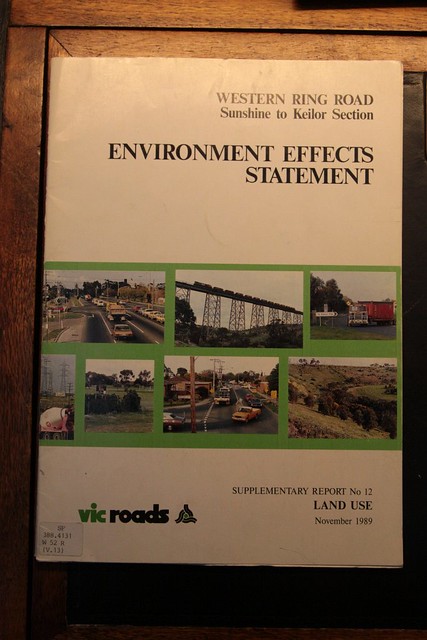
In ‘Supplementary Report No. 12’ dated November 1989, I found the following line:
The current Proposed Main Road reservation through Ardeer is to be deleted as the reservation width is considered insufficient to provide for a major arterial road.
It then goes on to recommend new usages of the now unneeded land:
The length of the reservation between the St Albans rail line and Derrimut is to be rezoned as follows:
(i). The section adjacent to Public Open Space reservations to the east and north of Hulett Street – to Public Open Space reservation.
(ii). The section adjacent to General Industrial Zone immediately north of Western Highway – to General Industrial Zone.
(iii). In Ardeer, from the Western Highway to Forrest Street amended to Proposed Secondary Road. An area immediately north of Forrest Street amended to Reserved Living.
(iv). From Ridgeway Parade southwards to Dalton Street rezoned to Reserved Living to allow residential development to take place subject to satisfactory road access arrangements. The present Proposed Secondary Road reservation (for the extension of Wright Street) will be retained until the long term development of the land is determined.
(v). South of Dalton Street a strip of land fronting Nicholson Parade is proposed to be rezoned to Reserved Living. This will ensure that the Sunshine West neighbourhood is not affected by industrial traffic intrusion if land to the west is developed for industry. The remainder of the old road reservation is proposed to be rezoned as Reserved Light Industrial to reflect present zoning to the west.Item (iii) above will enable the provision of a north-south access route which will greatly improve accessibility in this area, currently severely limited by lack of crossing opportunities over the rail line and Kororoit Creek.
The Council has yet to carry out detailed traffic and planning studies for Ardeer/Sunshine West. These may show the need for different zones or reservations in the area. Designation of the land as Reserved Living generally preserves these options. If the Council decides that a road is not required for it’s purposes on the existing reservation north of Forrest Street, the land would revert to its underlying zoning of Reserved Living; or some such other reservation that the Council may decide upon. Before rezoning of the land is approved, the potential for contamination of the site will be assessed.
With the route of the Western Ring Road through Ardeer now decided, construction started in the early 1990s, with the Keilor Park Drive to Western Highway section opening in July 1995, and the Western Highway to Boundary Road, Laverton segment in March 1996.

As for the land zoning changes, the Government Gazette dated 19 January 1995 detailed the final abandonment of the old freeway route.
Planning and Environment Act 1987
NOTICE OF AMENDMENT TO A PLANNING SCHEMEThe Brimbank City Council, Sunshine Office has prepared Amendment L79 to the Sunshine Planning Scheme. This amendment proposes to change the planning scheme by rezoning land along part of the abandoned Western Ring Road Reservation as follows.
(1) Parkland between Ridgeway Parade and Wright Street from Proposed Main Road Reservation to Public Open Space Reservation.
(2) Existing residential property at 164 Glengala Road from Proposed Main Road Reservation to Proposed Public Open Space Reservation.
(3) Part of Glengala Road from Proposed Main Road Reservation to Secondary Road Reservation.
(4) Existing residential properties in Hall Street and Lachlan Road from Proposed Main Road Reservation to Residential C Zone.
(5) Vacant land in Wright Street, Adina Court, Yaralla Count and Dalton Street from Proposed Main Road and Proposed Secondary Road Reservations to Reserved Living Zone.
(6) Vacant land in Adina Court from Proposed Main Road Reservation and Reserved Living Zones to Proposed Secondary Road Reservation.
(7) Vacant land in Fremont Parade and Marti Court from Proposed Main Road Reservation to Residential C Zone.This amendment can be inspected at the Brimbank City Council, Sunshine Office, Alexandra Avenue, Sunshine or the Department for Planning and Development (Plan Inspection Section, Ground Floor, the Olderfleet Buildings, 477 Collins Street, Melbourne) and will be available for inspection during office hours by any person free of charge. Submissions about the amendment must be sent to the Urban Planning Department, Brimbank City Council, Sunshine Office, Municipal Offices, Alexandra Avenue, Sunshine 3020 by Monday, 20 February 1995.
So that wraps up everything up, including the little house by itself at 164 Glengala Road, Sunshine West.
Further reading
- The short term effects of Melbourne’s Western Ring Road: a paper by Paul Mees

I did a field trip to the ring road with my fellow engineering students when it was under construction. There are quite a few interesting ‘features’ on the route such as: the kink in the road is more pronounced due to the need to avoid the protected and endangered Derrimut grasslands; there are two sections of ‘ground level bridges’ where the road passes over former landfill sites; the tunnel at the Jacana interchange was constructed using a novel push-through sheath method, which allowed the road and rail above to remain in place during construction.
That sure would have been an interesting site visit!
Regarding the ground level bridges, the Sunshine Tip site was one of them – it was located next to Jones Creek, on what is now the Carrington Reserve. The expansion gaps are quite visible on that section of the Western Ring Road.
As for the Jacana underpass, luckily the National Library of Australia has a number of photos of the construction works in their archives:
http://nla.gov.au/nla.pic-an20237759
The State Library of Victoria has larger versions of some of the above photos:
http://handle.slv.vic.gov.au/10381/170472
All up 18 precast inverted U shaped units were jacked up to 110 metres through the soil:
http://trid.trb.org/view.aspx?id=409042
[…] March 11 blog post on the kink in the Western Ring Road got a […]
“That wraps everything up” ???
It hardly seems a convincing explanation at all. Do you actually believe that strip of land isn’t wide enough for a main road ? I don’t. I thought you were going to reveal that that house belonged to Carl Williams’ granny, or something.
Using Google Maps, the reservation is 86 metres wide at Glengala Road, which spans from Collenso Street in the east to the back fences along the western side. South of Ballarat Road in Albion it is a similar width – 80 metres between two sets of back fences. Note that the transmission lines also use the reservation.
For the purposes of comparison, the six lane wide section of the Western Ring Road at Pipe Road in Laverton North uses a reservation 80 metres wide, albeit through an industrial area and with no parallel transmission lines also sharing the route.
Another comparison is the section of the Western Ring Road at the Currunghi Court footbridge in St Albans. There the reservation is 150 metres wide, with the freeway in a cutting, houses along both sides, and two sets of transmission lines following the western side of the alignment.
I heard it was insufficent space along with protests from residents. You also must remember between the Princes fwy interchange and the western hwy link that the median strip is still grass which will allow for a future expansion of the ring rd to 4 dedicated running lanes through these two interchanges, so in total there will be 5 lanes and one emergency lane in each direction to service this section. I can only think of one other interchange in melbourne that allows 4 dedicated running lanes in a fwy interchange and thats the monash fwy running over eastlink.
Jacana tunnel construction photos, if you’re interested.
https://www.dropbox.com/sh/ck7x61y7kcn3vm5/zXph9H0mLq
Thanks for that. It looks like they dug three pilot tunnels first, and built the foundations for the pipejacked sections inside them.
Thanks for the post.
Funnily enough I was just looking at the original proposed route in one of my old Melway’s and wondered why it was shifted to the west, then stumbled upon here.
There are still a few relics of proposed roads out there like this where no road is likely to ever be built.
That house on Glengala Road wouldn’t have to worry about waking up the neighbours!
Glad that you found the post being of use to you.
As to the house on Glengala Road – they don’t have to worry about neighbours, but they do have a lot of boundary fences to maintain!
[…] Ardeer and the kink in the Western Ring Road * […]
[…] open space through Sunshine West and Ardeer was originally intended to be used by a freeway – these plans were abandoned in the 1990s, and replaced by the current Western Ring Road […]
Do folks know about the Tait (Red Rattler) train carriage on the North side of Ballarat rd near where that electrical transmission line crosses?
(The voice of SmartBus 903 calls it Barlarrat Rd.)
It would be Tait carriage 490M – at the corner of Hulett Street:
During the environmental impact investigations the original freeway alignment was reviewed intensely as there was minimal width and the road had to share the corridor with the HV lines. It was decided that the width was not adequately considering the potential future road widening requirements, the existing HV line (albeit they could be moved to the side of the reservation), the noise and air quality impacts on the nearby residences, the various other controls like interchanges, grasslands, etc. I was part of the EES team at VicRoads managing some of the environmental investigations.
Thanks for that extra info Phil.
Maybe a question I’ve been asking for a long time could be answered here.
Why has there never been a bridge/road through from Ballarat Road to Ardeer ? It’s never made sense to me that there is only one way into Ardeer
Look forward to comments
Cheers
Hi, do we know if the new land was placed in an acquisition overlay or was it just acquired by the Govt. there a few properties along the new route that were cut in half and now have been land locked.
Which properties do you have in mind? Having a look at VicPlan what is now the industrial estates of Derrimut were cut off, but had roads connected as the area was developed.
https://mapshare.vic.gov.au/vicplan/?layerTheme=&scale=5000.010000020001&basemap=¢er=2480815.1536946893%2C2412712.99035638&layers=
Reid Street
Ah – that’s an interesting one!
https://mapshare.vic.gov.au/vicplan/?layerTheme=&scale=2500.0050000100005&basemap=¢er=2482615.2733900705%2C2415077.581188234&layers=
Lot 1 PS315806 north of the Western Ring Road is zoned IN3Z industrial, but address is “103 Reid Street, Ardeer” – a street on south side of the freeway.
Next door is Lot 1 PS315853 with address “18B Jonesfield Corner, Cairnlea” is similarly zoned – but it’s nowhere near that street, access would have to be via Lot RES1 LP96644, with the address “195B Denton Avenue, St Albans” and zoned PUZ1.
Landlocked parcel north of the freeway at 18B Jonesfield Corner, Cairnlea sold for $313.5k in 2012.
https://www.domain.com.au/property-profile/18b-jonesfield-corner-cairnlea-vic-3023
Either a data issue, or someone thinks they can find a way to access it.
South of the Ring Road 40 Reid Street, Ardeer was sold for $315,000 in April 1994 – presumably that government disposing of land once the freeway alignment has been secured.
http://house.speakingsame.com/p.php?q=Ardeer&sta=vic&id=751250&address=40+Reid+Street%2C+Ardeer
103 Reid Street and 18B Jonesfield Corner, Arder get a mention here:
https://www.brimbank.vic.gov.au/sites/default/files/council_minutes/2015/9c19d684-483b-430e-b62c-a48800a2e9be/Report_6.pdf
In 2010 a developer made an application under the EPBC Act to develop the land.
http://epbcnotices.environment.gov.au/_portal/modal-form-template-path/a71d58ad-4cba-48b6-8dab-f3091fc31cd5?id=657b7a12-4c67-e511-b4b8-005056ba00ab&entityformid=c2c88dfd-64a4-49bf-84fb-49edb9186137&languagecode=1033#
Industry south of the freeway.
http://epbcnotices.environment.gov.au/_entity/annotation/7019c33d-8569-e511-b93f-005056ba00a7/a71d58ad-4cba-48b6-8dab-f3091fc31cd5?t=1623900122388
And residential to the north, accessed via both Jonesfield Corner and Denton Avenue.
http://epbcnotices.environment.gov.au/_entity/annotation/54ea6637-8569-e511-b93f-005056ba00a7/a71d58ad-4cba-48b6-8dab-f3091fc31cd5?t=1623900122388
[…] I even managed in to slip in a bonus piece into the interview – why the Western Ring Road takes a kink around Ardeer. […]
[…] Which was once reserved for a freeway. […]