I was out in the Melbourne suburb of Sunshine West the other week when I found a roundabout to nowhere – with only one road in and one road out, there is no reason at all for it to exist!

Located in the middle of open parkland that also serves as a transmission line corridor, here is the roundabout on Google Maps.
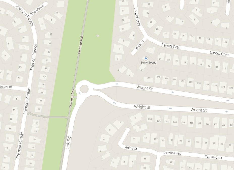
This is the view from Wright Street on the eastern side .

And from Link Road to the south.

If you go all the way back to 1966, Edition 1 of the Melway shows that Wright Street never went this far west.
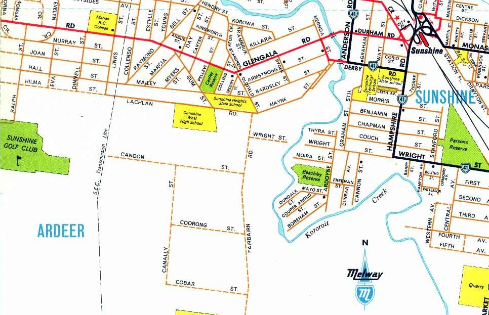
But by Edition 26 in 1999 Wright Street now terminated at a dead end beneath the transmission line corridor.

One can assume the roundabout was added when Link Road was constructed in the early 2000s, when it was intended for the road to continue further north, but the extension fell through.
Footnote
The open space through Sunshine West and Ardeer was originally intended to be used by a freeway – these plans were abandoned in the 1990s, and replaced by the current Western Ring Road alignment.

You know, it’s not as bad as it seems, perhaps there was a need to have a turning space at the end of the road, and so they simply just put in a roundabout at the end, so that traffic didn’t end up taking a left down a street for no purpose. Know what I mean? But, it’s still good future proofing design, it’s easy to connect up to a roundabout, rather then connecting to a dead end.
Now, what you should note is something funny that occurs in new estates, was walking down the road, and one of the roundabouts has a road that leads 5 meters then ends. This wouldn’t normally be an issue, except that in that 5 meter stretch someone decided to put a bus stop to nowhere, no route exists. The timing is funny, because estates can take many years, so this bus stop might never be used before something like the glass gets vandalised. Glass at a bus stop is consistently vandalised over time, the glass may never see a single bus before it’s destroyed.
I don’t have as much of a problem with this roundabout.
The turning space idea is one I didn’t consider, but it makes sense here – Wright Street has a median strip down the middle and houses on both sides, so some way for residents to head back the other way is essential!
You’ll find something similar at the Beaconsfield interchange on the Princes Freeway with a one road in-out roundabout with the old freeway spur now taken over by the Pakenham Bypass. A westbound exit ramp was not built but was planned for, as was an extension of the former freeway connection to connect with nearby O’Shea Road which itself would be widened.
I’ve passed through the Beaconsfield interchange many a time, but had forgotten all about it.
https://www.google.com.au/maps/place/Beaconsfield+VIC/@-38.0620272,145.369775,857m/data=!3m1!1e3!4m2!3m1!1s0x6ad619416caf5785:0x5045675218ce080
Another roundabout to nowhere – on the Murray Valley Highway to the east of Wodonga:
https://www.google.com.au/maps/@-36.1203885,146.9110331,349m/data=!3m1!1e3
More finds, this time from Queensland – Walter Hay Drive in Noosaville:
https://www.google.com.au/maps/@-26.4193462,153.0507283,570m/data=!3m1!1e3
And the main street of Airlie Beach:
https://www.google.com.au/maps/@-20.2690792,148.7196186,19.71z
Another roundabout to nowhere from New South Wales – Newcastle Link Road and Minmi Road outside Newcastle:
https://www.google.com.au/maps/@-32.9023525,151.6216009,286m/data=!3m1!1e3
Hi Marcus.
I’d managed to miss this page before. But here’s another roundabout (admittedly an odd shape for one) that I’ve known about for a while. It’s on Phillip Island and its sole purpose seems to be to allow U-turns to be safely carried out near a school.
https://www.google.com/maps/@-38.5092371,145.3536154,181m/data=!3m1!1e3
Continuing this tangent, here is something similar on Balfour Road in Drouin at the end of a one-way road.
https://www.google.com.au/maps/@-38.1424403,145.8821998,235m/data=!3m1!1e3