With all of the recent talk about the construction of the Melbourne Metro rail tunnels beneath Swanston Street and the Yarra River, it seems that many people have forgotten how our last major tunnel project was built – CityLink.
CityLink consists of two tunnels – the shorter Domain Tunnel that carries westbound traffic, and the longer Burnley Tunnel that carries eastbound traffic – with roadheaders being used to construct the majority of each tube. However at each end of the tunnel, the project faced the same problems as the Melbourne Metro tunnels.
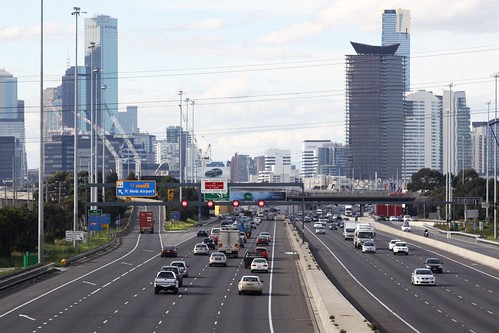
At the western end of both tunnels is Grant Street and St Kilda Road, full of both road and tramway traffic.

Here a ‘top down’ methodology was adopted while digging the massive hole.

Excavations for cut & cover works at Grant Street May 1998 (Ian Hill, SLV image H99.20/24)
The 2002 book Journey and Arrival: The Story of the Melbourne CityLink published by the Institution of Engineers, Australia elaborates:
The conventional cut-and-cover method was not used at the Grant Street portal, in part to accommodate the impact on the adjacent Victorian College of the Arts (VCA). The size of the excavation necessary for cut-and-cover was huge: 35 metres wide and progressively increasing in depth to about 25 metres at St Kilda Road.
The top-down technique used along Grant Street involved the installation of columns along the alignment of the outer walls of the tunnels, and along the centre line which would ultimately form the barrier between the two tunnels. This was achieved by drilling holes about 900 mm in diameter to bedrock, and then backfilling the holes with concrete. A concrete beam was then constructed along the top of the columns to form the support for the tunnel roof. Once the spans were in place, Grant Street was reinstated and excavation took place unimpeded beneath the deck.
The top-down variation of the cut-and-cover method also reduced the disruption on St Kilda Road, a major thoroughfare with busy tram lines. In fact tram services were closed on only one weekend. The crossing of St Kilda Road was undertaken in stages. Initially the outer service roads were closed and traffic was diverted to the central roadway. This allowed the construction of the columns and tunnel roof in the same manner as along Grant Street. However, extensive propping was necessary under the surface to support the columns against the 25 metre depth of soil pressure. Once work on the outer service roads was completed, traffic was re-diverted to allow work on the central part of the road.
Meanwhile at the east end of the Domain Tunnel was the Yarra River, which passed only a few metres above the future tunnel roof.

It was decided to build the river crossing in two stages, with a coffer dam being used to keep the water out while allowing the river to keep flowing.

Coffer dam construction in Yarra River for Domain Tunnel 26/4/97 (Ian Hill, SLV image H99.20/10)
Again, Journey and Arrival: The Story of the Melbourne CityLink gives the technical details:
The construction of the cut-and-cover crossing of the Yarra River represented some of the cleverest engineering of the whole project. Essentially, a trench had to be cut in the riverbed, the tunnel built in it, and the riverbed placed back on top.
As these works could not proceed easily underwater, the river had to be diverted away from the riverbed worksite during construction. The most efficient way to do this, while ensuring minimum disruption to river flows and traffic, was to work on the crossing in two parts: initially shutting off about two thirds of the river from one bank, and, when completed, switching to the other bank, then closing the other third of the river to complete the process.
What does it mean for Melbourne Metro?
Back in April 2015 how to built the Melbourne Metro tunnels beneath the Yarra River was still unresolved – possible solutions being an immersed tube tunnel, or CityLink style cut and cover using a coffer dam.
This week the final solution was announced – a tunnel boring machine would do the work, with the tunnel running to the east of Princes Bridge, around seven metres below the riverbed, and 11 metres below the surface.
More photos of CityLink
The State Library of Victoria holds the ‘Melbourne City Link Project Series‘ – images taken by photographer Ian Hill during the construction of CityLink.
- Concrete pour for roof of Domain Tunnel inside coffer dam in Yarra River
- Grant Street entrance for Domain Tunnel showing cut & cover works
- Entrance to Domain Tunnel at Grant Street
There is a lot more technical details in Journey and Arrival: The Story of the Melbourne CityLink – I’ve just scraped the surface in this post.
VicRoads also have an interesting CityLink related document on their website – Exhibit I Project Scope and Technical Requirements.

A couple of other relevant resources:
http://www.fitzgeraldconstructions.com.au/projects_sub.php?id=224&cat=3
https://books.google.com.au/books?id=KuUtzTWzN-8C&pg=PA158&lpg=PA158&dq=how+deep+is+domain+tunnel&source=bl&ots=p_BTV8rr5c&sig=qFHmBrL-k1k23a3owOXfCgCyPPY&hl=en&sa=X&ei=_0E4VfajEKHwmAXFqYG4BQ&ved=0CFMQ6AEwCQ#v=onepage&q=how%20deep%20is%20domain%20tunnel&f=false
Some nice finds there – I haven’t seen photos of the cofferdam from that angle before.
As for the second one, it provides plenty of detail about the various emergency exit pathways. 😉
A couple more tunnel-related links:
Catalyst story about Sydney’s new Northwest Rail Link, under construction. It includes tunnel and viaduct sections. This story is about the tunneling.
http://www.abc.net.au/catalyst/stories/4132605.htm
In the late 1980s and early 1990s, MMBW tunneled the Western Trunk Sewer to replace the aging, ground level Main Outfall Sewer, between Brooklyn and Werribee. As an engineering student on work placement at the Board of Works in 1990, I visited the tunnel while it was under construction. A video about the project was produced – I can’t find a copy published, but here’s a catalogue link:
http://trove.nla.gov.au/work/21201565?q&versionId=45433362
John Holland played a role in the project:
http://www.cimic.com.au/__data/assets/pdf_file/0017/10574/JHG_TunnellingBrox.pdf
ATS is an excellent resource for tunnel-rats!
http://www.ats.org.au
http://www.ats.org.au/index.php/resources/tunnel-dbs/165-australian-tunnels/file
I can remember as a kid seeing the big pink building at the Hoppers Crossing pumping station take shape – it was right next door to the freeway on the drive from Geelong to Melbourne.
Channel 9 aired a documentary on the construction of Citylink before its opening in 1999 which I uploaded to YouTube late last year after I found the video of it I still had. In it they discuss the tunnel boring and the cut and cover sections – under St Kilda Road and under/through the bottom of the Yarra as you discussed above.
https://www.youtube.com/watch?v=fQ2lQPSQ9Sk
It seems my scepticsm about the open cut tunnel I made before was right on – I could never quite see cut and over tunnel under the Yarra, existing rail lines and the Swanston Street/Flinders Street without enormous disruption to city traffic on top of the Swanston Street tram services. One need only look at the excavation for Museum station in the 1970’s to see what is involved for a major open cut underground station.
Not to mention that Swanston Street passes over the top of the railway tracks at Flinders Street Station via an aging deck – the ‘Flinders Street Station Concourse Rehabilitation’ project patched it up about a decade ago:
http://www.eptec.com.au/Projects/InfrastructureProjects/FlindersStStation3.aspx
That “top down” method is also how the Boronia (Boronia/Dorset Roads – and what is now the supermarket carpark) grade separation was done, I think.
Some good photos of the work at Boronia in 1998 is here:
http://www.westonlangford.com/search/?q=Boronia
Here’s a 3D Google Maps which gives a different view:
http://i.imgur.com/29bMQ4p.jpg
Google does an impressive job at their 3D views, plus they’ve scrubbed out cars on the road!
The other big (longer?) tunnelling project in recent years was the Northern Sewer project. There was a TBM involved with that, I think, and although it didn’t involve the slushy ground near the Yarra it was still a major undertaking, although perhaps less glamorous and of no immediate interest to the citizenry!
Quite a project – three TBMs to bore 12.5 kilometres of tunnel 3 to 4 metres deep!
http://www.johnholland.com.au/our-projects/northern-sewerage-project
Not quite as long, but complex due to the river crossing was the Melbourne Main Sewer replacement project:
http://www.johnholland.com.au/our-projects/melbourne-main-sewer-replacement
Just like CityLink, they used a cofferdam to cross the Yarra River, this time beside the Charles Grimes Bridge.