If you think Melbourne is a city already strangled by freeways, then this 1954 proposal for a City Ring Road will surely make you feel that we dodged a bullet.
Included as part of the 1954 Melbourne Metropolitan Planning Scheme, the City Ring Road was for a controlled access road that would encircle the entire CBD, West Melbourne, and what is now considered Docklands and Southbank.

The Melbourne and Metropolitan Board of Works described what they saw as the problem.
From the study of the movements of traffic within and adjacent to the central business area of the city it is apparent that much unnecessary traffic enters the area.
The traffic census carried out in 1947 under the auspices of the Town and Country Planning Board showed that about 50% of the total traffic which entered this area daily passed straight through to destinations elsewhere. At peak periods most of the traffic on Princes Bridge and Spencer Street Bridge, and a substantial portion on Queen’s Bridge is through traffic.
This results from the following important traffic movements:
(a) Between the northern and western suburbs and the industrial district and shipping berths of the river.
(b) Between the shipping and rail terminals and the industrial areas of the inner eastern suburbs.
(c) The increasing volume of traffic between the shipping and rail terminals on the one hand, and the industrial areas in the west and at Geelong, the industrial areas developing to the south-east, and the Latrobe Valley on the other hand.
(d) Substantial worker and general traffic between the southern and northern suburbs.At present this considerable volume of through traffic has no reasonable alternative other than to pass through the central business district. To reach its destination it has frequently to make right-hand turns which not only mean loss of time, but which add to the general congestion and the slowing down of other traffic. Investigations indicate that the proportion of through traffic will tend to increase and thus accentuate the problem.
And then presented their solution.
Traffic conditions in the central area would be vastly improved if this through traffic were diverted, for besides reducing the number of vehicles using the streets it would also lessen the amount of turning traffic.
The City Ring Road (Route 1) has been planned, therefore, to permit this through traffic to by-pass the busy city centre, to facilidate the distribution of incoming traffic to the central area, and to act as a collector for outgoing traffic and give it expeditious access to the arterial road system.
Along with how it would be implemented.
If this road is to achieve its purpose, it must offer traffic an inducement to use it in preference to passing straight through. In practice, therefore, it must provide for free and uninterrupted movement to compensate for any greater distance that may have to be travelled.
It is visualised that eventually it will need to have grade separation structures or roundabouts at all important junctions, and that it will be essentially a road with controlled access. It is realised that this final development will not be justified for many years, but the route chosen is one which can be developed progressively. Most of the roads are already 99 feet wide, sufficient to accommodate traffic for some time, provided it is properly controlled. The Spring Street – Victoria Street section is already used
extensively as a by-pass route.
As well as widening existing road corridors, two new road bridges over the Yarra River would be required.
A crossing over the river between Blyth Street, West Melbourne, and Johnson Street, South Melbourne, which is the most urgent portion, would relieve Spencer Street of about one-third of its traffic, and is therefore warranted immediately.
Construction of the crossing over the railway yards between Alexandra Avenue and Spring Street would complete the ring. Improvement at the various intersections could then be carried out when justified by the volume of traffic using the route. This road is the key to the proposed road communication system and of the greatest importance to the future of the central business area.
So what happened?
As you might expect, planning for a freeway along Spring Street past the steps of Parliament House didn’t go down well, so the route was soon moved to Lansdowne Street in East Melbourne.
But that introduced a new problem.
The route then proposed in the 1954 planning scheme and incorporated in the board’s interim development order followed Lansdowne Street. When examined in more detail, it was found that the effect of such a route on the Treasury and Fitzroy Gardens adjoining Lansdowne Street would be most undesirable.
A third alignment was then tried.
Another alternative examined much farther to the east passed very close to the Melbourne Cricket Ground and followed Powlett Street.
And then a fourth.
The route finally selected followed Clarendon Street and was considered to be the best of all alternatives offering. In 1963, the necessary amendment to what was then the metropolitan interim development order, to reserve land for the new Clarendon Street route, was made public, and objections were raised.
Passing right beside the Ponsford Stand of the MCG.

Which then underwent multiple revisions, until finally approved.
The Government favoured further examination of the alternative to modify the Clarendon Street plan, and finally the plan was approved by the Governor in Council in 1968. This was plan 7. We have come a long way from plan 4.
By 1971 the eastern section of the City Ring Road was being re-examined, following the release of the 1969 Melbourne Transportation Plan:
A Cabinet sub-committee had been investigating the material put forward by objectors and voluntary organizations, and had been examining the Melbourne transportation plan with a view to considering what parts of it should be implemented.
It recommended that the eastern leg of the ring road should be rejected, on the grounds that the project would have created a considerable disturbance to the charm, character and environment of the area through which it was planned, and that more acceptable and less costly alternatives to serve Melbourne’s transport needs could be achieved.
But that didn’t mean it wasn’t to be replaced by another freeway.
It also recommended that priority be given to a further detailed investigation of all implications of a freeway which had been called F2 and which was proposed in general terms as a north-south by-pass somewhere to the east of Hoddle Street in a location which is certainly far from decided.
As well as completion of the western half of the City Ring Road as freeway.
The sub-committee recommended that the Government give priority to the construction of the freeway known as F14, which will provide Melbourne with a north-south by-pass link with the Tullamarine Freeway, and a crossing of the Yarra River west of Spencer Street.
But these recommendations didn’t immediately kill off the eastern City Ring Road.
The MMBW proposal was subsequently modified in 1971 to the development of a 6 lane freeway commencing at Wellington Parade, moving southwards across the Melbourne Cricket Ground parking area, Brunton Avenue, the railway yards and the Yarra River, and passing beneath the Domain and St Kilda Road and re-surfacing in Grant Street.
Construction of the proposed link was scheduled to commence in the late 1970s. However, following a request from the then Minister for Local Government requesting a re-examination of the proposal, it was subsequently abandoned and the planning scheme reservation through the Domain was removed in 1975.
But even that wasn’t enough to completely kill off the proposal – a few decades later it came back in a different form – the Exhibition Street Extension. Announced by the State Government in April 1998 and completed in October 1999, this four lane divided road over the Jolimont railyards linked the upgraded CityLink tollway at Swan Street to the Melbourne CBD at Flinders Street.

Proposals have also been made to upgrade Hoddle Street to a controlled access road, by grade separating intersections along the route, or building a tunnel under the entire road.
And to the south and west
The western and southern parts of the City Ring Road both featured in the 1969 Melbourne Transportation Plan – with the F14 freeway providing a north-south bypass of the CBD via a crossing of the Yarra River west of Spencer Street, and the F9 freeway forming an east-west bypass through South Melbourne.
Work on the southern half commenced as part of the Lower Yarra Crossing project – better known as the West Gate Bridge. The first stage of the freeway opened between Lorrimer Street in 1978 along with the West Gate Bridge, with a second stage east to Stuart Street opening in 1987, and a connection to the South Eastern Freeway built as part of CityLink ‘Southern Link’ and opened in 2000.
The western half of the City Ring Road was completed in 1975 with the opening of the Charles Grimes Bridge, which linked an upgraded Footscray Road on the north bank of the Yarra to Montague Street on the south.
This route was duplicated by Bolte Bridge and the ‘Western Link’ section of CityLink in 1999. In conjunction with the Melbourne Docklands development, during 1999-2001 Footscray Road was closed as a through route, Wurundjeri Way constructed as a replacement north-south route, and the Charles Grimes Bridge rebuilt to connect with it.
And the last piece of the puzzle?
The only portion of the City Ring Road that has never been built was the northern half along Victoria Street, but the on-again off-again East West Link fills the same need.
Unfortunately this cartoon by Ron Tanberg grows more accurate year by year.

And a note on ‘City Bypass’ signs
Melway Edition 22 from 1993 included a “Central Melbourne Bypass & Access Routes” map for the first time – with VicRoads having installed matching signage about the same time.

Note the similarities between this and the 1954 City Ring Road proposal.
Footnote – route details
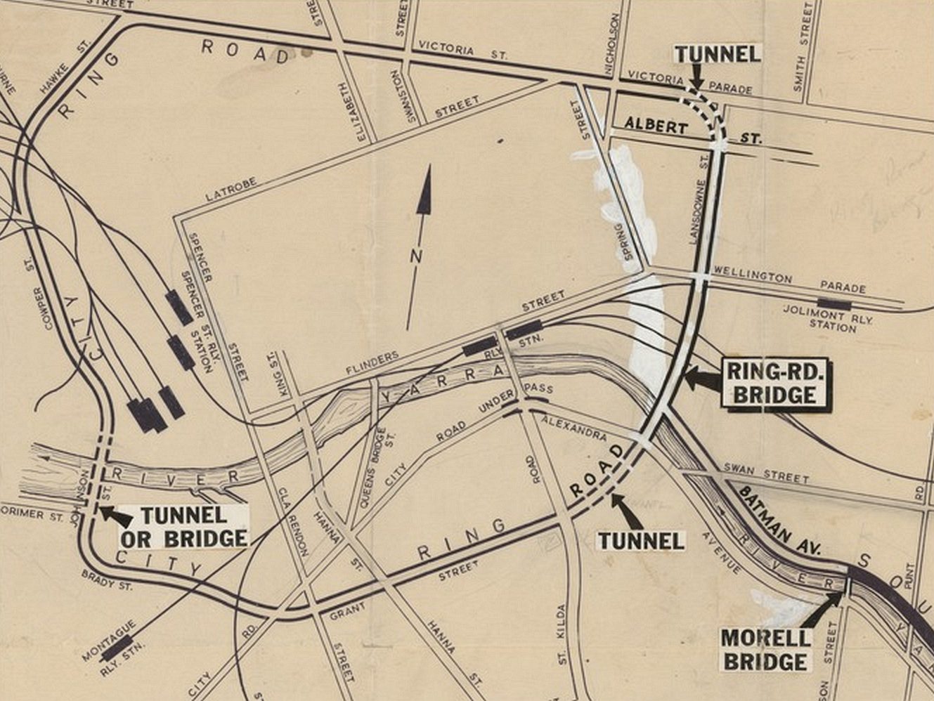
The 1954 Melbourne Metropolitan Planning Scheme described the proposed City Ring Road route as such.
From the roundabout (1) at the corner of Victoria and Nicholson Streets the road would follow Victoria Street westwards, passing over Rathdown Street (2) and under Lygon Street (3). From Cardigan Street it would be carried in a viaduct (4) over the junctions of Victoria Street with Swanston and Elizabeth Streets to near Queen Street.
It would continue along Victoria Street and Hawke Street, which would be joined with Cowper Street by a bridge (5) over the railway yards and the road junction at Dudley Street. The road would continue along Cowper and Blyth Streets and cross the river, probably by a movable type bridge (6), to the important junction with Route 3 at Johnson and Brady Streets.
Eventually, traffic at this point would warrant direct connection by viaduct (7) with Grant Street. The road would continue along Grant Street, where it would form portion of the approach road from the deep-water port to the city business centre.
Crossing under St. Kilda Road and portion of the King’s Domain to Alexandra Avenue, it would then be carried across the river and railway yards by bridge (8) to Spring Street, which from the south side of Collins Street to the north side of Bourke Street would be depressed (9) to avoid interruption to the movement of its traffic by vehicles from Collins and Bourke Streets.
And the 1969 Melbourne Transportation Plan
The 1969 Melbourne Transportation Plan also featured a City Ring Road – note the differences in the north-west corner, as well as the eastern side through Yarra Park.
![]()

I remember seeing some maps about this when looking through the SLV catalogue. I can’t find the one I remember, but did find these:
Map of rejected routes through East Melbourne: http://handle.slv.vic.gov.au/10381/223747
Map of the proposed road from East Melbourne to South Melbourne: http://handle.slv.vic.gov.au/10381/223403
View of Jolimont with the proposed road indicated: http://handle.slv.vic.gov.au/10381/223514
Planning for the South Eastern Freeway in relation to the ring road: http://handle.slv.vic.gov.au/10381/117432
Some fantastic finds there Stephen – thanks for sharing!
The 1954 plan seems to point at more a large capacity arterial road system with a kind of semi freeway look closer to the city looking at the City Ring Road plan (a mixture of flyovers and roundabouts, plus the previously posted St Kilda Junction flyover) and the detail of the suburban plan in Part 3
https://www.planning.vic.gov.au/__data/assets/pdf_file/0021/26085/Part-3.pdf
For example the Monash Freeway alignment is only planned to Oakleigh as I noted in a previous post with Dandenong Road upgraded to dual carriageways and service roads which was ultimately done by the early 60’s – note the indicative cross sections on page 95 of the above link. The Dingley Freeway (Routes 25 and 26, later F2) was included there to Cheltenham Road in Keysborough with local upgrades and a smaller bypass of Dandenong South planned until the early 60s when the current reservation was set. Westall and Springvale Roads (Route 7 later F7) only ever really had a reservation for a divided arterial and full freeway standard would be a squeeze in the 1969 plan. Back then they acknowledge the lack of a proper reserve for the southern Nepean Highway and the alternate route along Wells Road which became the Mornington Peninsula Freeway.
North and west of the city the current Ring Road can be seen as an amalgam of limited access and existing arterial roads (Route 5 later F5) as well as the never built sections of Route 3 and Route 16 which was to be the F3 Hume Freeway.
The ‘not quite freeway’ seems to be a common theme throughout the 1954 plan – I wonder what caused later plans to go for full controlled access?
That 1954 plan looks exactly like the ring roads proposed and generally built for every UK city and town – you can look at Google Maps for any town, and see some kind of wide arterial with various roundabouts, usually lined by 50s / 60s slab or tower blocks in open space. Though mostly they just ploughed through ‘slum’ inner city or even actual commercial areas rather than bothering with any tunnels.
There are a few town centres in Victoria with similar arterial roads rings around them – Footscray and Mornington come to mind.
Well, the benefit is we could have converted it into a fantastic cycleway and orbital tram line later on.
Do you know about PRT at Heathrow airport? I thought that would be the future of transport – 1470 mm wide pods that drive themselves and use up not much space at all.
ie, convert a 3 metre wide road lane into 2 PRT lanes that are fenced-off from normal cars.
It is enough of a strugle to take a single lane from Hoddle Street to create a full time bus lane – what makes you think that if Melbourne had a ring road that the public would accept losing road space to create a cycleway and orbital tram route?
As for Personal Rapid Transit systems – it’s a future that never seems to arrive…
https://www.theverge.com/2016/2/24/11094524/prt-transit-history-self-driving-cars-alden-starrcar-tomorrowland-1960s
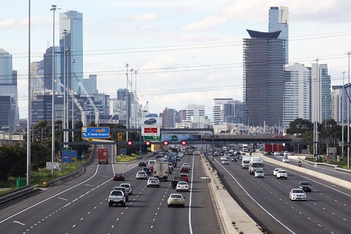
Meanwhile, the effort to pave Melbourne continues…
https://www.facebook.com/NoNorthEastLinkA/
“Dodged a bullet” ?? That ring road would have been excellent ! Better than what exists now, where there is no limited access road around the north or east side of the CBD.
[…] Melbourne was in the middle of a road building spree, including the City Ring Road and the Swan Street Bridge – completed in […]