A recent theme on my blog has been “zombie subdivisions” – suburbs that were created but never took off, resulting in empty streets in the middle of nowhere. It turns out Victorian planing policy has an official name for them – “old and inappropriate subdivisions” and a method of dealing with them – “restructure overlays”.

Starting in the land boom of the 1880s, and continuing until the introduction of formal planning controls in the 1950s, speculative subdivision of land into small blocks, many less than 0.1 hectares (1/4 acre) was rampant across Victoria.
These estates lay empty until the 1970s, when improved road access and the outward expansion of Melbourne saw pressure to develop these empty blocks, which saw the State Government fund the restructuring of inappropriately subdivided areas, a process that continues today through a “Restructure Overlays” applied to the affected land.
Failed speculative estates turned industrial
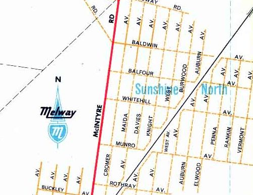
The first zombie subdivisions I found was Solomon Heights in Sunshine North – subdivided for residential purposes but related rezoned as industrial.
A similar example is the ‘Burns Road Estate‘ in Altona – subdivided in the 1920s, but never developed.

Closer to home for me are two Geelong examples – ‘New Station Estate‘ on Broderick Road – since restructured as larger industrial allotments.

And ‘New Corio Estate‘ on Shell Parade – purchased by council to become a grassland reserve.

Land boom hits Whittlesea
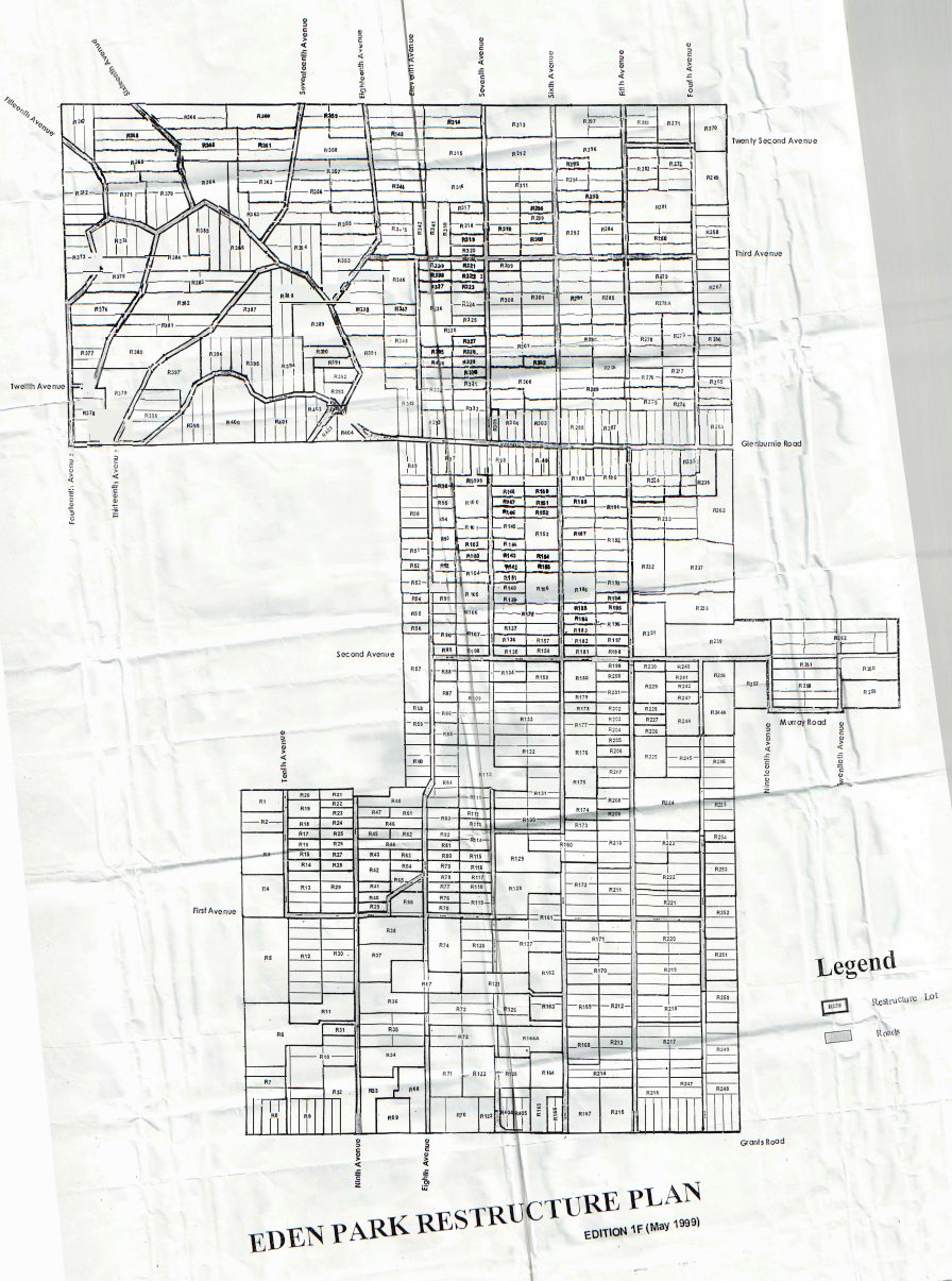
Eden Park west of Whittlesea was develpped during the 1880s land boom.
The subdivision of Eden Park sits six kilometres to the west of Whittlesea and 40 kilometres to the north of Melbourne. It is located between the lines of a geometric grid that in 1888 was prepared by the Burwood Land Building and Investment. Co. Ltd. The development featured 1324 lots, ranging from one to four acres in size.
But was unsuitable for such intensive development.
By 1901 upwards of 100 persons of small means had acquired lots at Eden Park, some no doubt tempted by the subdivider’s persuasive description of the advantages of a rural retreat.
In time many owners sold or surrendered their holdings by adverse possession until about 30 families owned small farms, intersected by the estate’s avenues. In the late 1960s the estate was again actively promoted, and in 1980 there were 450 individual owners and 175 detached houses.
Resulting in the restructure of the estate as a rural living area.
Created by bureaucratic bungling
Cemetery Estate in Hastings – approved for housing in 1960 with 230-plus lots sold. The Long Island Point gas fractionation facility was then built next door, rendering the unsuitable for residential development. Six households and 100+ privately owned allotments remain today.

And victims of dodgy developers
Midway between Werribee and Rockbank is Chartwell Estate – a subdivision created in the 1950s and marketed to new English migrants, and since restructured in the 1980s to facilitate limited residential development.

Swallowed by suburbia
The township of Kalkallo is located on the northern edge of Melbourne, on the Hume Highway just north of Craigieburn, and predates current planning rules.
The Kalkallo township was established in the pre-1851 squatting era and is an excellent examples of early rural town settlement. The township was subdivided into small allotments without regard for the provision of services or the effects of inadequate effluent disposal. As a result many of the allotments are incapable of adequately supporting a dwelling.
So as Melbourne has crept towards the township, a restructure overlay has been placed over it, to ensure that sympathetic development occurs.

Fire hazards
In the hills east of Melbourne, the Yarra Ranges Council is worried about the bushfire risk.
The objectives of the Restructure Plans under the Restructure Overlay are to:
- Ensure that existing old and inappropriate subdivisions are restructured in a manner that reduces development densities, that provides development opportunities consistent with the capacity of the site and the area to absorb such development without adverse impact on the environment and landscape of the area and without creating undue social and utility servicing pressures.
- Ensure that the restructure of old and inappropriate subdivisions assists in achieving environmental and landscape objectives for the area generally and that development of these lots is environmentally sensitive in its siting, design and construction.
- Ensure that adequate and proper servicing arrangements are made whilst recognising that there are often environmental impacts and high costs associated with infrastructure and utility service provisions.
- Recognise that restructure lots generally have poor accessibility and are often in isolated locations removed from community and other service facilities.
- Recognise that restructure areas are often located in high fire hazard areas and that any new development must be sited and designed to minimise fire hazard.
The end result – a total of 134 separate restructure overlays.

Holiday homes by the beach
I discovered Summerlands Estate of Phillip Island and the mysterious “This area is subject to a Government acquisition program” note alongside as a child. Developed from the 1920s in the middle of the penguin habitat, environmental concerns saw the “Summerland Estate Buy-Back Programme” launched in 1985, that saw the entire suburb wiped off the map by 2010.

The nearby ‘Scenic Estate’ was a similar situation – again redeveloped as a nature park.

The same concerns apply along the Victorian coast.
Old and Inappropriate Subdivisions along the coast is an issue that planning has been attempting to deal with for some time. Most subdivisions occurred prior to formal planning laws being introduced. Issues being grappled with include: potential coastal erosion; climate change impacts; and development thresholds.
Point Roadknight near Anglesea is an uncontentious example.
The Anglesea Neighbourhood Character Study (2003) identified two areas in Point Roadknight where the lots are substantially smaller in width and site area to the general pattern of allotments in the area.
Lots in the area adjoining Great Ocean Road are approximately 9.3m wide and have an area of 523m². Lots fronting Eighth and Eleventh Avenues are approximately 9.3m wide and have an area of 417m². This compares with the predominant lot size of 1000-1500m² in the surrounding areas. These lots result from past inappropriate subdivision, and in the majority of cases are owned in groups of two or three, with an existing dwelling constructed across the boundaries of the lots.
The Study flagged that if the lots in these land parcels were to each be developed individually for a dwelling, or re-subdivided to facilitate this outcome, it would result in an adverse impact on the character of the surrounding area. A recent example of the type of development being discouraged is at 59 Eighth Avenue, where the boundaries of two lots (each 417m²) were realigned to facilitate the construction of two dwellings, resulting in a crowded development that is uncharacteristic of the area.
Since restructured.

Landowners fight back
Attempts to restructure land in South Gippsland saw landowners fight back – Toora being one example.

But the Wellington Shire Council’s handling of Ninety Mile Beach subdivisions went to the Victorian Ombudsman:
The story of the development of Ninety Mile Beach is a sorry tale indeed. Thousands of people, mostly migrants, lured by developers with the promise of their own slice of paradise on Victoria’s own Gold Coast. The brochures promise a well-planned resort, with shopping centres and amenities, illustrated by pictures of glamorous women in bathing costumes on the golden sands.
Then as the years wear on the promises unravel. Much of the land cannot be developed, at least in its present form. Some of it is beach dunes. Some of it is flood-prone. Much of it is inaccessible. Successive environmental studies confirm what should have been seen at the outset, that it should never have been sold off in the first place. The original developers have disappeared.
In the meantime, some owners have continued to pay rates and other charges on their now worthless slices of paradise. Others have refused to pay. Yet others have sold their land back to the council for the nominal sums reflecting the land’s current value, later accusing the council of profiteering. In recent years the anger and frustration of many current and former landowners seems to have escalated, and to date has resulted in 67 complaints to my office.
Since then it has been recommended that blocks on coastal dunes and in flood-prone areas should be acquired by the State Government, while those in ‘urban settlement nodes’ can be developed, but only if the original individual lots are combined with three others to form a single block.
Impacts on agriculture
In Melbourne’s outer east Cardinia Shire Council has seen inappropriate subdivisions encroach on agricultural land.
In the area south of the Princes Highway, there are also many areas that were subdivided into 20 acre parcels as part of the draining of the Koo Wee Rup Swamp. These areas often contain high quality productive soils and many are within the Koo-wee-rup Flood Protection District, therefore they are subject to regular flooding. Many of the lots are also held in contiguous ownership and are being farmed as one farming unit.
It is considered that the development of housing on lots at the density of the original subdivision will compromise the long term agricultural productivity of the land and would substantially alter the character of the area. The Restructure overlay has been put in place to restrict the number of dwellings being constructed on lots that are in contiguous ownership.
The Mount Alexander Shire Council has similar concerns in the Victorian gold fields, where farmland around Ravenswood, Muckleford and Maldon is at risk of being developed for residential uses.
The lots in these areas mainly comprise old Crown Allotments which are significantly smaller than the minimum lot size allowed under the Farming Zone (40 hectares) and which if developed with dwellings could lead to the entrenchment of these areas as rural living areas.
This is not supported because it would remove land from productive agricultural use and in many cases will also be incompatible with the environmental values of the areas. In addition, some of the areas are relatively remote from townships and services.
Conditional on access
In the Shire of Murrindindi restructure plans, development of one allotment is conditional on access being approved to the Maroondah Highway.

While another restructure allotment is reserved to provide access to a neighbouring parcel that is landlocked.

And protecting townships in the middle of nowhere
In the south-west the Colac Otway Shire has restructured subdivisions in Cressy, Gerangamete, Pirron Yallock and Irrewillipe.

The Surf Coast Shire has restructured the outskirts of Deans Marsh.

South Gippsland Shire restructured historically envisaged railway and port settlements, and State Government land settlement schemes from the late 19th century.

As well as former coalmining townships.

And the Pyrenees Shire in western Victoria have put in place restructure overlays on the townships of Avoca, Wattle Creek, Beaufort and Snake Valley, amongst others.
And the most bizarre example
Sandstone Island is a 20 hectare island located one kilometre southeast of Hastings, which was bizzarly subdivided into 142 suburban-sized allotments during the 1960s.
Sandstone Island is rural freehold land held in single ownership and is isolated and constrained by its geographical location and lack of infrastructure. The Island is bordered by steep, grassy coastal bluffs. The Island contains an existing dwelling and shed and there is no provision for tourism or commercial uses.
So the restructuring of them into a single allotment was an obvious solution.

The legal bits
The Victoria Planning Provisions detail what a “Restructure Overlay” is.
Restructure Overlays are shown on the planning scheme map as RO with a number.
Purpose
- To implement the Municipal Planning Strategy and the Planning Policy Framework.
- To identify old and inappropriate subdivisions which are to be restructured.
- To preserve and enhance the amenity of the area and reduce the environmental impacts of dwellings and other development.
Subdivision
- A permit is required to subdivide land.
- A subdivision must be in accordance with a restructure plan for the land listed in the schedule to this overlay.
- Each lot must be provided with reticulated sewerage if available. If reticulated sewerage is not available, the application must be accompanied by a land assessment report which demonstrates that each lot is capable of treating and retaining all waste water.
Decision guidelines
Before deciding on an application, in addition to the decision guidelines in Clause 65, the responsible
authority must consider, as appropriate:
- The objectives of the restructure plan for the area.
- Appropriate measures to cope with any environmental hazard or constraint affecting the land, including slope, drainage, salinity and erosion.
- The protection and enhancement of the natural environment and the character of the area including the retention of vegetation and fauna habitats and the need to revegetate along waterways, gullies, ridge lines and property boundaries.
- The availability of utility services, including sewerage, water, drainage, electricity, gas and telecommunications.
- The relationship of the intended use and development to the existing or likely use and development of adjoining and nearby land.
- The effect on surrounding uses, especially agricultural uses and nearby public land.

[…] As well as an overarching post covering the subject of ‘old and inappropriate subdivisions’ in Victoria. […]
Great work on the record. Migrants were so often sold these dodgy development lots, especially the one I am quite familiar with, the Ninety Mile Beach development.
That one was quite the saga:
https://www.ombudsman.vic.gov.au/our-impact/news/a-sorry-tale-indeed-ombudsman-calls-for-end-to-saga-affecting-owners-of-ninety-mile-beach-land/
Really interesting blog. I’ve long been aware of the 90-mile beach subdivision. There’s another huge zombie subdivision west of Metung as well. The Shoalhaven region in NSW also has some notable examples.
Tambo Bluff at Metung?
https://tblc.org.au/wp-content/uploads/2016/10/Tambo-Bluff-Community-Newsletter-No.-01-Spring-2016.pdf
http://www.riddellscreeklandcare.org.au/projects/protection-of-barrm-birrm
Another one behind Riddells Creek
Thanks for that!
You beat me to it by a few months. I came here to tell Marcus about Barrm Birrm.
How does one approach the council to buy back the land? I own a block of land in bunyip with a restructure overlay on it. Which seems ridiculous as it’s a flat block of land and all I would like to do is build a house on it. Already has shed and septic tank permitted on the block. Any information or help would be greatly appreciated. Block of land is on southbank rd bunyip. My tenement states I need 9 other blocks to build which is not optional. There’s also another parcel of land up the road same overlay different tenement.
Regards Mick
That are looks like Restructure Overlay RO51 on the local planning scheme:
https://planning-schemes.api.delwp.vic.gov.au/__data/assets/pdf_file/0009/467235/cardinia23ro.pdf
I’d expect odds of council opting to buy the land are low – leaving you to either assemble 9 more lots into something you can build on, or sell to someone else trying to do the same.
Talking to a property conveyancer or solicitor might also help.