When you look at a map of Melbourne’s older suburbs, a grid network of streets dominates. However on edge of the western suburb of Newport is an interesting street layout – with ‘The Circle’ in the middle, and streets radiating out at 45 degree angles.

Google Maps
The story starts in the 1927, when the open paddocks between Mason, Mills and Hansen Streets and Blackshaws Road were subdivided for speculative development.

1929 Plan for General Development
The 2017 Hobsons Bay Heritage Study stating.
This estate was originally made up of two Lodged Plans, LP 12379, and LP 12834, which were subdivisions of Crown Portions C & D, Section 6. They were declared by solicitors, Bullen & Burt, lodged by the surveyor GT Little (later Little & Brosnan) in 1927, and the consent of Council was given in the same year. The official stamp was given in 1929 and there was even a ‘Little Street’ included in the plan named after the surveyor.
However the Metropolitan Town Planning Commission then became involved, and the street layout was redesigned.

1929 Plan for General Development
In what became a poster child for new subdivisions in the 1929 ‘Plan for General Development’.
Many subdividers and owners of land in the past have viewed with suspicion the efforts to induce them to adopt town planning principles. In some instances subdivisions which are intended to be town planning layouts are fantastic, and do not comply with requirements from a general development standpoint; in other cases they are extremely wasteful, and not in the interests of the city, the future residents, or the owners. These “so called” town planning schemes have retarded the general adoption by many owners of more scientific subdivision of land.
As examples of the above, the plans on page 261 are submitted. Scheme “A” the layout which was surveyed and forwarded to the Council for approval and seal in accordance with the usual practice, and the sealing was duly authorized. Prior to the subdivision of this area, the Commission had given considerable attention to the problem of road transportation in the western suburbs, and had adopted a general scheme of thoroughfares. This scheme was not known to the subdividers nor to the Council at the time this particular subdivision of the area was approved by the Council. As the approved subdivision seriously affected the Commission’s scheme, the subdividers were approached, and although they had incurred the considerable costs of subdivision and had received the approval of the Council as required by existing law, so satisfied were they with the proposal that they agreed to replan the area in accordance with the Commission’s general scheme.
Scheme “B” shows the amended subdivision, including two main roads, ‘”The Highway” and “Broadway”, each 84 feet in width. The general design of the subdivision is a marked advance on the old checker-board layout which was previously intended, and is an excellent example of the benefits to be gained by adequate control.
It should not, however, be necessary to amend plans on which large sums have been spent,and usually subdividers are loth to change their plans when expense has been entailed. Those who do are to be commended for their interest in the development of the metropolis on sound lines, and they are realising that it pays them to do so.
Some sources state that the estate was planned by Walter Burley Griffin’s Company, though the heritage study states that it is more likely the work of well-known planner, Saxil Tuxen.
In the years that followed little happened – this 1945 aerial photo shows empty paddocks.
Victorian Department of Lands and Survey photo map
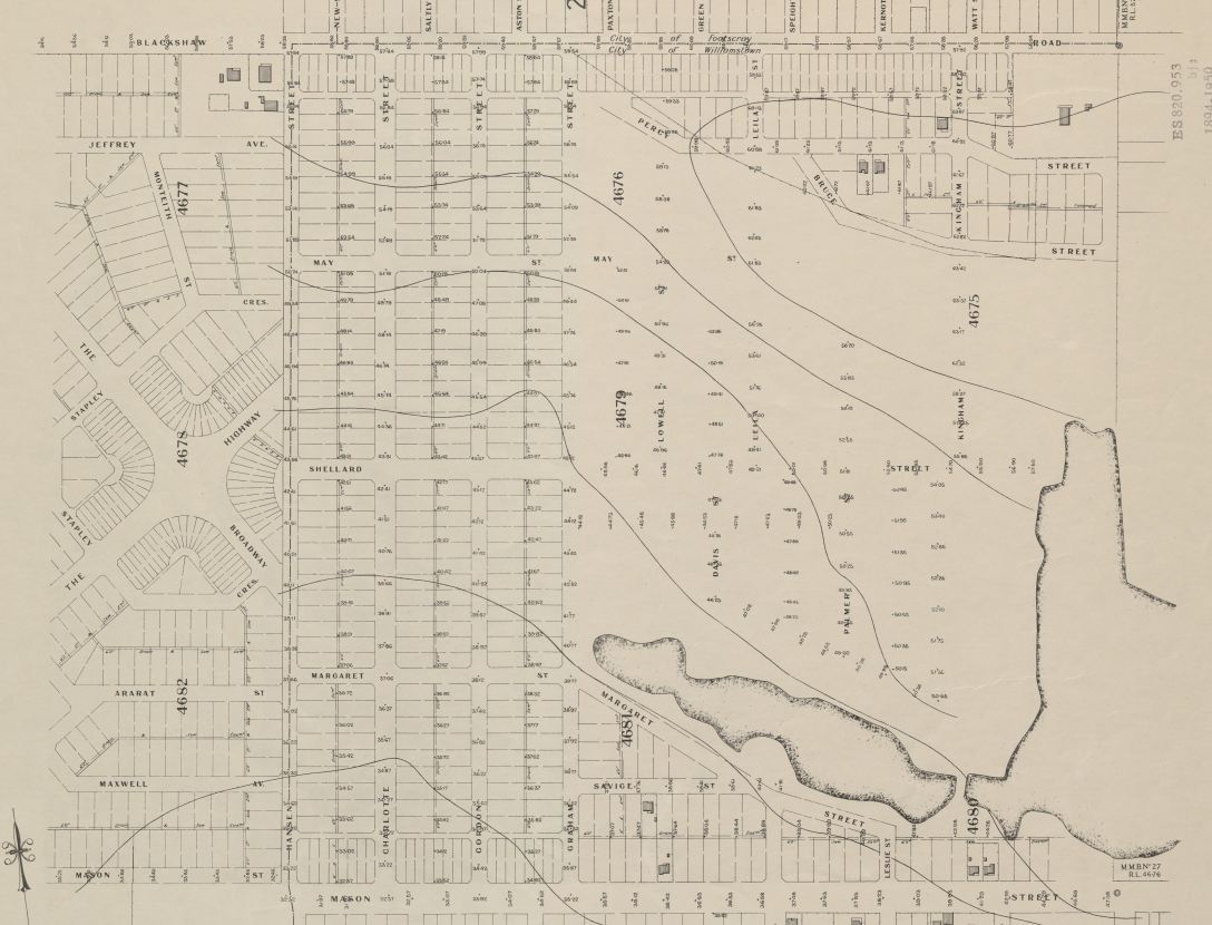
And this MMBW plan from 1947 reinforces this – a sea of empty streets, with the nearest houses back at Newport station.
However the end of WW2 saw development take off, land along Blackshaws Road first to be sold from the mid-1950s.

The Age, 28 February 1955, page 8
Real estate agents promoting Newport West as “the district of the future”.

The Age, 11 October 1958, page 45
Land sales soon ramped up.

The Age, 18 July 1959, page 40
And supporting infrastructure followed soon after, including a Dutch speaking doctor who set up shop at The Circle, and a library branch in 1966.

The shopping centre was finally built out by 1970.

The Age, 28 March 1970, page 48
Resulting in the suburb of 1950s weatherboard and 1960s brick veneer houses seen today.

Google Maps
Footnote
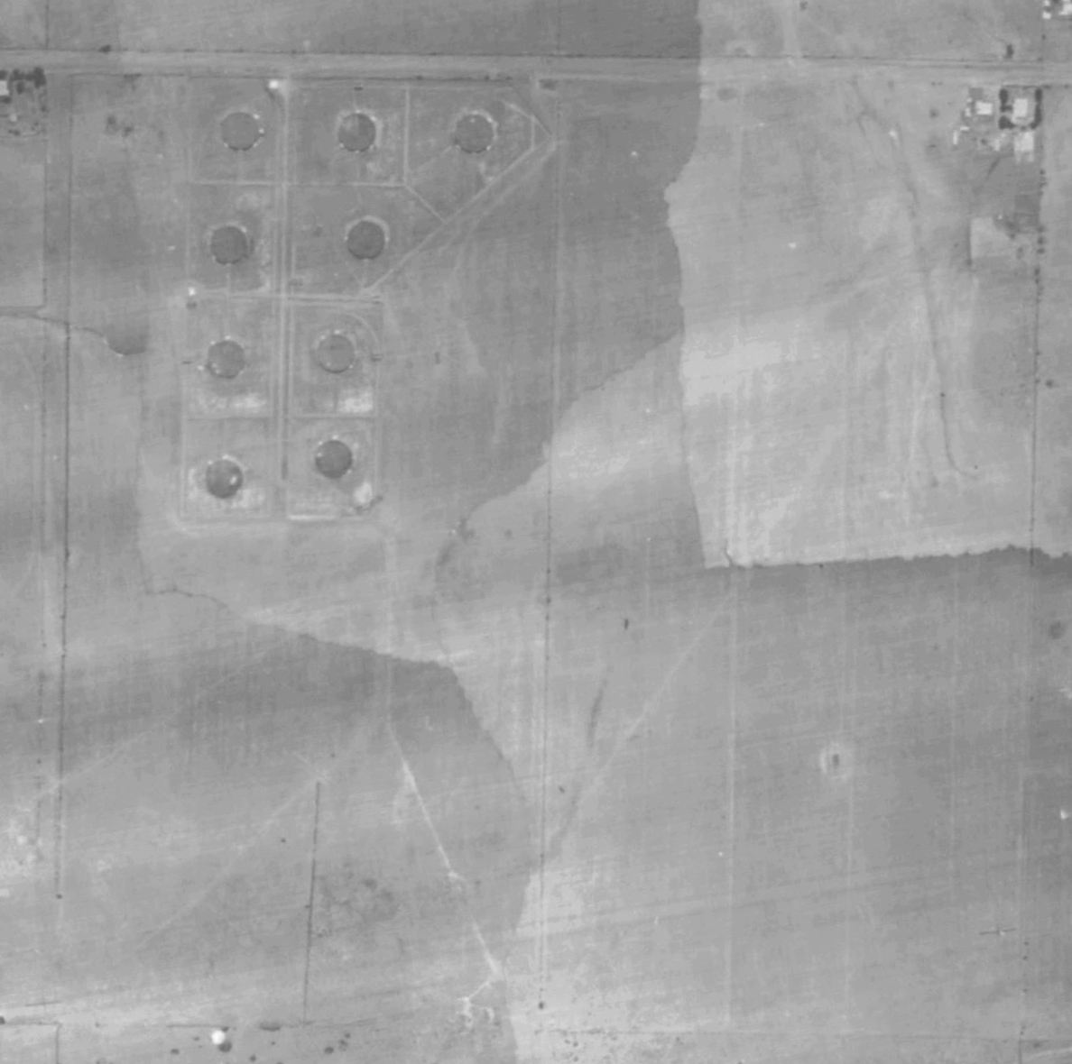
The 1945 aerial photos shows nine large circular tanks located at the north west corner of the estate, at the corner of May Street and Blackshaws Road. I’ve got no idea what they were for – any ideas?

Victorian Department of Lands and Survey photo map
And an update
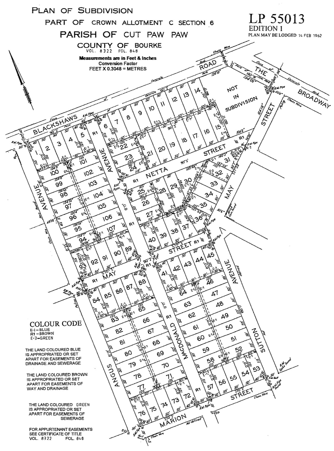
I dug up the plan of subdivision for the area once occupied by the mysterious tanks – it was lodged in February 1962, and B.P Australia of 131 Queen Street, Melbourne was the vendor.
So oil tanks it is!

It’s almost certainly a world war 2 oil storage dump.
If I went out on a limb, I’d suggest aviation fuel for the nearby bases at Point Cook and Laverton.
If I went even further out on the fragile branch of assumptions, I’d suspect that the tanks were in-ground tanks. Military planners went out of their way not to build above ground things in straight lines as a straight row of things were too vulnerable to a single straffing run. (Have a look at the WWII ammunition base near the Maribrynong River on the Albion – Broadmeadows railway line on the same aerial maps.)
I’d previously heard of the RAAF’s inland aircraft fuel depots from WW2, but none of them were in this area.
https://en.wikipedia.org/wiki/List_of_RAAF_inland_aircraft_fuel_depots
Yes, I would have to agree. The symmetry reeks of the military. No doubt for oil or refined product storage. I wonder if any local residents have any ideas as to what they were?
Oh, and I’d suggest the facility is where Netta St is now, extending southwards to Marion St.
Note the odd diagonal boundary fence on the eastern side of the aerial photo. This
appears to lead to a 90 degree bend to a second diagonal boundary fence leading to Blackshaws Rd, matching May St & The Broadway.
Even in a wartime emergency, and in undeveloped paddocks, it’s easier and cheaper to resume existing surveyed blocks than resurvey.
I wonder if the council or local residents know anything of the property’s history?
The Victorian Railways purchased “three 6000 ton capacity concrete tanks” on Newcastle Street, Newport from the Commonwealth Government in 1947.
https://trove.nla.gov.au/newspaper/article/63257737
They don’t appear on the 1945 aerial photo, so perhaps the address was incorrect or the street once continued further west?
maybe the image was airbrushed out/substituted for an older one due to the war, as it may have been a air-b*mbing risk. Basically similar to what Google Earth does for high risk locations nowadays. The Department of War would have likely identified it as a high risk site, and potentially edited any aerial pictures of the site.
Another reference from 1946.
https://trove.nla.gov.au/newspaper/article/245380293
“Oil for naval vessels was stored in the tanks during the war. Pipe
lines and pumping and switch houses will also be available to the railways. Oil will be pumped from the wharf into the tanks.”
Ships were built at Newport during the war, perhaps they were storing the fuel there to pump to the VR. Alternatively, maybe it was the first stage of the establishment of Newport as a fuel hub.
Interesting that the centre of the radial pattern was not in the centre of the development. Maybe there was an unsuccessful attempt to influence the development immediately to the east?
I wonder how good the post-tank decontamination was?
The development of this subdivision and subdivisions to its south (particularly the latter) should have led to the construction of a Newport South station near/incorporating the Newport South signal box at Champion Rd.
Marcus, with reference to the nine large circular tanks adjacent to Blackshaws Rd, they look to me like water storage tanks or maybe part of a sewage treatment plant.
That’s as far as my thinking takes me.
Paul O’Connor