Over the years there have been many examples of pilots confusing one airport for another, and Melbourne has seen more than it’s fair share – thanks to Melbourne Tullamarine Airport being located near Essendon Airport.

Google Earth
14 January 2014
Air India flight AI301
Boeing 787-8 VT-ANM
.jpg)
From the Carry-on blog.
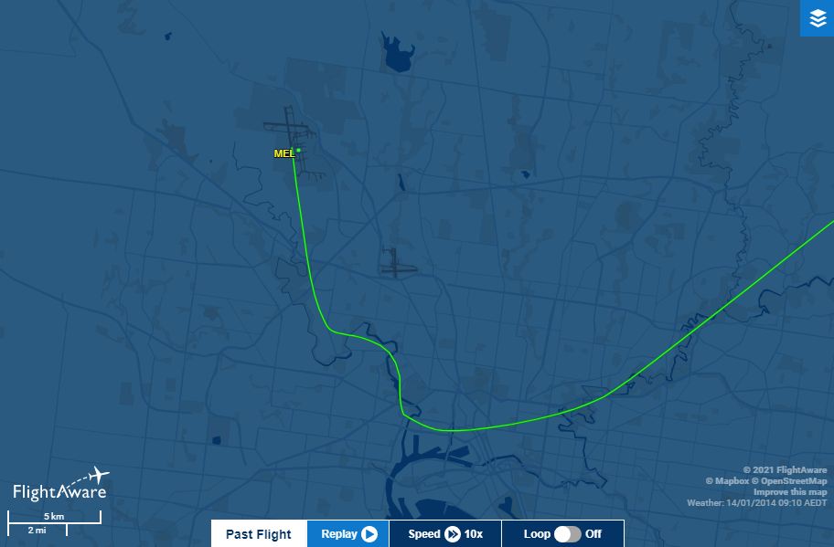
Operating AI301 from Sydney to Melbourne VT-ANM approached and crossed Melbourne from the east following usual tracking paths for aircraft inbound from the north-east to YMML’s active Runway 34.
The flight crew initiated a right turn to lining up for Essendon’s Runway 35 mistaking it for YMML’s Runway 34.
Sources in Airservices Australia confirm the flight crew discontinued the approach at roughly 1,050 ft after being notified by Melbourne Approach, made a left turn, climbed to 1,500 ft and re-established a second approach this time to Runway 34.
The missed approach is easy to see on the flight track.
FlightAware flight tracking log
31 March 1994
Australian Airlines
Boeing 737-300 VH-TJA
.jpg)
Note: not the same 737 as this incident
From the ATSB investigation.
At about 18 NM from Melbourne, the crew were requested by air traffic control to report when the Melbourne runway was in sight. The crew reported they had that runway in sight and were cleared to track to join final inside 8 NM from Melbourne.
The crew requested and were given further track shortening until they were instructed to make a visual approach for runway 34 and to call Melbourne Tower. The Approach Controller then diverted his attention to other duties for a short period.
On rechecking the progress of the aircraft it appeared, to him, to be on final for runway 35 at Essendon. The aircraft was at an altitude of approximately 1500 feet. The Approach Controller advised Melbourne Tower who instructed the aircraft to turn left for Melbourne. The aircraft subsequently landed without further incident.
The flight crew subsequently advised that when they were given the visual approach they believed they had the Melbourne Airport in sight and its position was confirmed by checking the map displayed on the aircraft flight management computer. However, they had not used any other aircraft navigational systems to confirm their position in relation to Melbourne.
24 February 1991
Lufthansa
Boeing 747-400 D-ABTC
.jpg)
From the ATSB investigation.
The aircraft, which was approaching Melbourne Airport from the west, was radar vectored onto base leg and descended to 3000 feet.
At 1704 hours Melbourne Approach Control advised the crew that their position was nine miles south-west of the field. They were asked to advise when they had the runway in sight and also to say when the runway 34 lead in strobe lights were sighted.
Shortly after, the crew responded that they had the runway and strobe lights in sight. Approach Control gave the crew their position as six miles south-west of the field, told them to make a visual approach and not to descend below one thousand five hundred feet until established on final.
At 1706 hours the controller told the crew they were approaching the runway extended centre line. The Approach Controller noted that the aircraft was passing through the extended centre line and had not turned to line up with runway 34. He promptly issued instructions to the aircraft to climb to 2000 feet. At about the same stage the crew realised that the runway they had been looking at was too short for their operations and also decided to go around. Further radar vectors were given and the aircraft subsequently landed normally on runway 34 at Melbourne without any other problems.
Runway 35 at Essendon Airport was the runway sighted by the pilots. It does not have lead in strobe lights. The crew indicated they must have seen reflections near Essendon which they mistook for strobe lights.
On the approach the crew had seen a runway from a long way out, which they thought was the north/south runway for Melbourne Airport, but was in fact runway 35 at Essendon Airport. In the lighting conditions at the time they did not see Melbourne Airport, until on the go around.
On the approach the minimum height descended to was just over 1000 feet above the elevation of Essendon Airport.
8 August 1987
Singapore Airlines flight SQ31A
Boeing 747-200, 9V-SQM

From the ATSB investigation.
On arrival in the Melbourne area the aircraft was vectored by Air Traffic Control (ATC) to a left base position for an approach to runway 34.
At a point 5 nautical miles (9.2 kilometres) south of the airport, and 1 mile (1.7 kilometres) to the left of the extended centreline of the runway, the aircraft was instructed to turn left to take up a north-easterly heading. The crew reported at this time that “we have the field visual.”
The aircraft was then instructed to make a visual approach, and to turn further left for a direct approach to the runway. The crew acknowledged this instruction, but the aircraft was observed to pass through the extended centreline. ATC advised the aircraft that it was now to the right of the centreline, and instructed it to turn left onto a north-westerly heading to intercept this line. The aircraft landed without further incident.
The Captain of the aircraft later advised that he was familiar with the Melbourne/Essendon area. Appropriate navigation aids had been selected to monitor the approach.
The Captain reported that he had initially mistaken Essendon for Melbourne, because the latter had been obscured by rain and low clouds. However, the crew became suspicious when the navigation aids did not confirm the visual indications. They were in the process of correcting the situation when ATC instructed the aircraft to turn to the left as it had passed the extended centreline. The crew had then sighted the Melbourne runway complex and had proceeded visually.
13 May 1987
Air New Zealand
Boeing 767-200ER, ZK-NBC
.jpg)
From the ATSB investigation.
The aircraft was radar-vectored for an approach to Melbourne (Tullamarine) Runway 34. The flight crew reported they were “visual” when at 2000 feet and about 17 kilometres (9 nautical miles [nm]) south east of Melbourne.
The Approach Controller advised the flight of its radar position in relation to Melbourne and requested confirmation that the crew had Runway 34 in sight. When this was acknowledged, instructions were given for the flight to take up a heading of 320 degrees; to intercept the extended centre line of Runway 34 from this heading; and to make a visual approach.
Shortly afterwards the Tower Controller at Essendon Airport (5 nm south east of Melbourne) called the Melbourne Approach Controller and reported that a heavy aircraft was on approach for (Runway 35) Essendon.
The Approach Controller called the aircraft, requested its present altitude and, on being advised it was “through fifteen hundred” (feet), instructed the flight to climb to 2000 feet and turn left onto a heading of 320 degrees. He also advised that the aircraft was 7 nm south east of Melbourne and still two miles to the right of the runway centre line.
Shortly afterwards, the flight crew reported they were at 2000 feet and had “Runway 34 Melbourne in sight”. The aircraft was then cleared for a straight in approach and for transfer to the tower frequency. The aircraft landed without further incident.
The flight crew have confirmed that they initially turned towards Essendon but detected their error at about the time the Approach Controller instructed them to turn (back) to 320 degrees and to climb.
30 December 1985
Qantas flight QF36
Boeing 767-200, VH-EAJ
.jpg)
From the ATSB investigation.
Air Traffic Control of the aircraft was being exercised by Melbourne Approach, which was directing the aircraft for a landing on Runway 27 at Tullamarine. The controller obtained approval from the Essendon controllers to vector QF36 through Essendon airspace.
The aircraft was progressively descended and when clearing the aircraft to descend to 2000 feet the controller advised the crew that the aircraft was 4 miles to the left of the runway extended centre line. The crew advised that they had visual contact with the ground and were then cleared to continue a visual approach.
Shortly afterwards, the crew sighted a runway and commenced a turn to the left, during which visibility reduced as the aircraft entered a rain shower.
On passing through the shower, the crew immediately realised that they had turned towards Essendon, and a right turn was carried out to continue tracking towards Tullamarine.
When the premature turn was commenced, it was observed on radar by the Approach controller and visually by both the Melbourne and Essendon Tower controllers. The Approach controller queried the aircraft intentions at about the same time as the crew commenced the turn back towards Tullamarine.
A normal landing was carried out about 3 minutes later.
19 June 1985
Garuda flight GA898
Boeing 747-200, PK-GSB
,_Netherlands_PP1167309002.jpg)
From the ATSB investigation.
Garuda Flight 898, was being radar vectored by Melbourne Air Traffic Control (ATC) for a landing on runway 34 at Tullamarine Airport. Shortly after the pilot acknowledged an instruction to call Melbourne Tower the aircraft was seen to turn and descend as though making an approach to runway 35 at Essendon Airport.
The Melbourne Tower controller instructed the aircraft to climb to 3000 feet above mean sea level (AMSL), and a few seconds later the aircraft was seen to be established in this climb. After further radar vectors were given, an uneventful landing was carried out at Melbourne.
It was subsequently determined that the aircraft had descended to a minimum height of approximately 350 feet above the level of Essendon Airport, and was about 1.5 kilometres from the runway threshold before the climb was commenced.
So why is it confusing?
Until the 1960s Essendon Airport was Melbourne’s main international gateway.

But today it is mainly used by business jets and light aircraft.

But mid-sized jets such as the Fokker F70 can also safely operate into the airport.
From the 1,921 metre long east-west and 1,504 metre long north-south runways.

Google Earth
Which just so happen to be a similar orientation to the 2,286 metre long east-west and 3,657 metre long north-south runways at Melbourne Tullamarine.
Google Earth
This similarity has been noted by ATSB investigators.
There have been a number of instances where Essendon has been mistaken for Melbourne. The two airports are in close proximity and have similar runway configurations. In this instance the flight crew members were not very familiar with the Melbourne area or with the approach to Runway 34.
Who recommended the following back in 1987.
It is recommended that consideration be given to the following
– 1 Operators briefing the relevant flight crews on the real possibility of misidentifying the two airports.
– 2 Operators instructing flight crew to make full use of available radio aids on visual approaches to Melbourne.
– 3 The Department of Aviation providing visual and/or radio aids to assist ready identification of Runway 34, such as sequenced strobe lights leading to the threshold and/or an instrument approach facility to the south of the airport.
The largest aircraft ever to land at Essendon Airport were a handful of Boeing 707s back in the 1960s – I’d hate to see what would happen to a Boeing 747 that tried to do the same.
Spot the difference
One spotting feature is the different strobe lights pattern at each airport – Essendon Airport’s beacon flashes white every four seconds – Melbourne Airport’s beacon flashes alternate white/green.
While the aerodrome charts also feature a warning – “WARNING: Secondary airport (Essendon) 5NM south-east”.

Airservices Australia – Aerodrome Charts
And Melbourne Airport runway 34 now has a distinctive identifier – three sets of sequenced white strobe lights commencing 485 metres from the end of the runway, and aligned with runway 34 centreline.

Airservices Australia – Aerodrome Charts
Footnote: freeway confusion
A hazard for pilots landing at Essendon Airport at night is the freeways that surround the airport.

An issue raised by the ATSB in a 2017 investigation.
The airport has two runways aligned 17/35 and 08/26, and it is bounded on two sides by freeways with substantial amber lighting and well-lit residential areas. At night, the lights around the airport present a complex picture. The published aerodrome chart had a caution note describing that amber freeway lighting may confuse flight crews when attempting to identify runway 08/26 lighting.
Computer confusion too
On 10 March 2015 an AirAsia flight from Sydney to Malaysia ended up having to divert to Melbourne when the pilot entered the wrong initial coordinates into the inertial navigation system.
.jpg)
And some unsourced stories
I found this story online referring a supposed incident around 1996.
About 5 years ago I was flying in the circuit in a little PA-28 at Moorabbin. It appeared to me that there was a B747 on long final. My flight instructor flicked the freq to Melbourne International, and sure enough, Alitalia 747 was lined up on the Moorabbin runway (which is less than 1.6 km long!) and complaining that he had visual but his navaids were all wrong. Melbourne Airport cleared him for a visual landing but then cancelled the clearance when they saw where he was on radar!
Further readingThey were also aware of anecdotal accounts of a DC-10 lining up to land on the Essendon runway sometime in the 70s, and being warned off at the last minute.
- An even longer list of mistaken approaches to Essendon Airport
- Boeing 737 at Essendon Airport? –
Sydney Airport Message Board - 100th Anniversary of Essendon Airport – Aviation Spotters Online
- Flightpaths and building heights around Melbourne Airports
- Wrong Runway, Wrong Airport, Wrong Country – OpsGroup
- Runway confusion – Flight Safety Australia

Once incident is too many, and after reading of so many incidents I think I have instantly developed a fear of flying.
On the upside each time the plane landed safely, air traffic control having told the pilots to correct their approach.
Wow. 7 in 36 years. This sounds like such a big issue.
The number of incidents slowed down by 1991, with one in 1994, then none for 20 years – I’m guessing the addition of runway strobe lights at Melbourne Airport addressed the source of confusion.
YMEN has almost identical length to NZWN so 747’s wouldn’t have any trouble landing at or leaving.
Runway 16/34 at Wellington is 2,081 metres long, but at Essendon pilots are confusing the 1,504 metre long north-south runway for Melbourne.
On the other hand, the usable runway at Wellington is much less – with 130 m (430 ft) and 106 m (348 ft) displaced thresholds at the north (16) and south (34) ends.
https://en.wikipedia.org/wiki/Wellington_Airport#Runway