If you’ve lived in Melbourne for a while you’ll know that the city is divided up into a number of local government areas, each responsible for community facilities such as libraries and parks, maintenance of local roads, town planning and development approvals, and local services such as waste disposal. However until 1994 Victoria’s regional cities were also split up between an array of cities, shires and boroughs.

Let’s take a tour
Today covered by the City of Greater Geelong, Geelong used to be part of multiple local government areas – the City of Geelong, City of Geelong West, City of Newtown, City of South Barwon and Shire of Corio making up the urban areas, with the urban fringe managed by the Rural City of Bellarine, and parts of the Shire of Barrabool and Shire of Bannockburn.
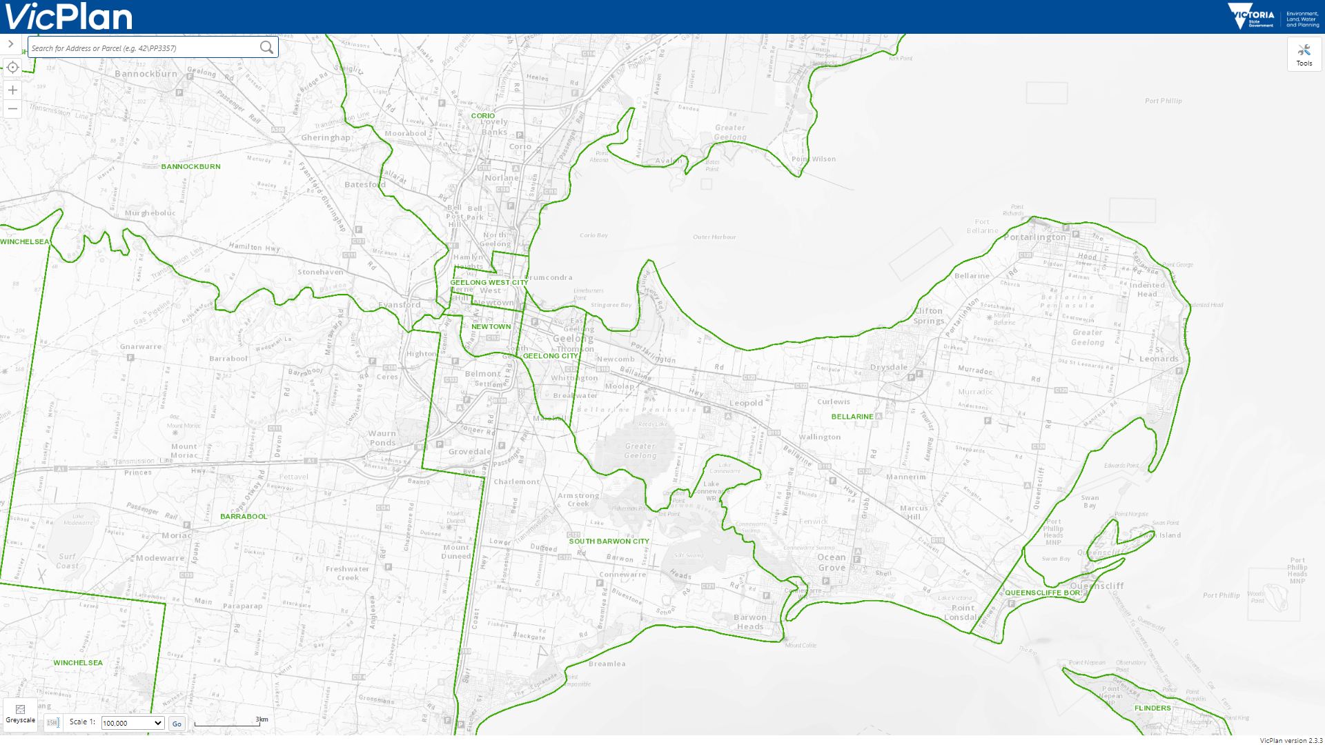
VicPlan map, Local Government Areas pre-1994 amalgamations layer
Ballarat was similar – today’s City of Ballarat was once the City of Ballarat, Shire of Ballarat and Borough of Sebastopol covering the city, with parts of the Shire of Bungaree, Shire of Buninyong, Shire of Grenville and Shire of Ripon covering the outskirts.
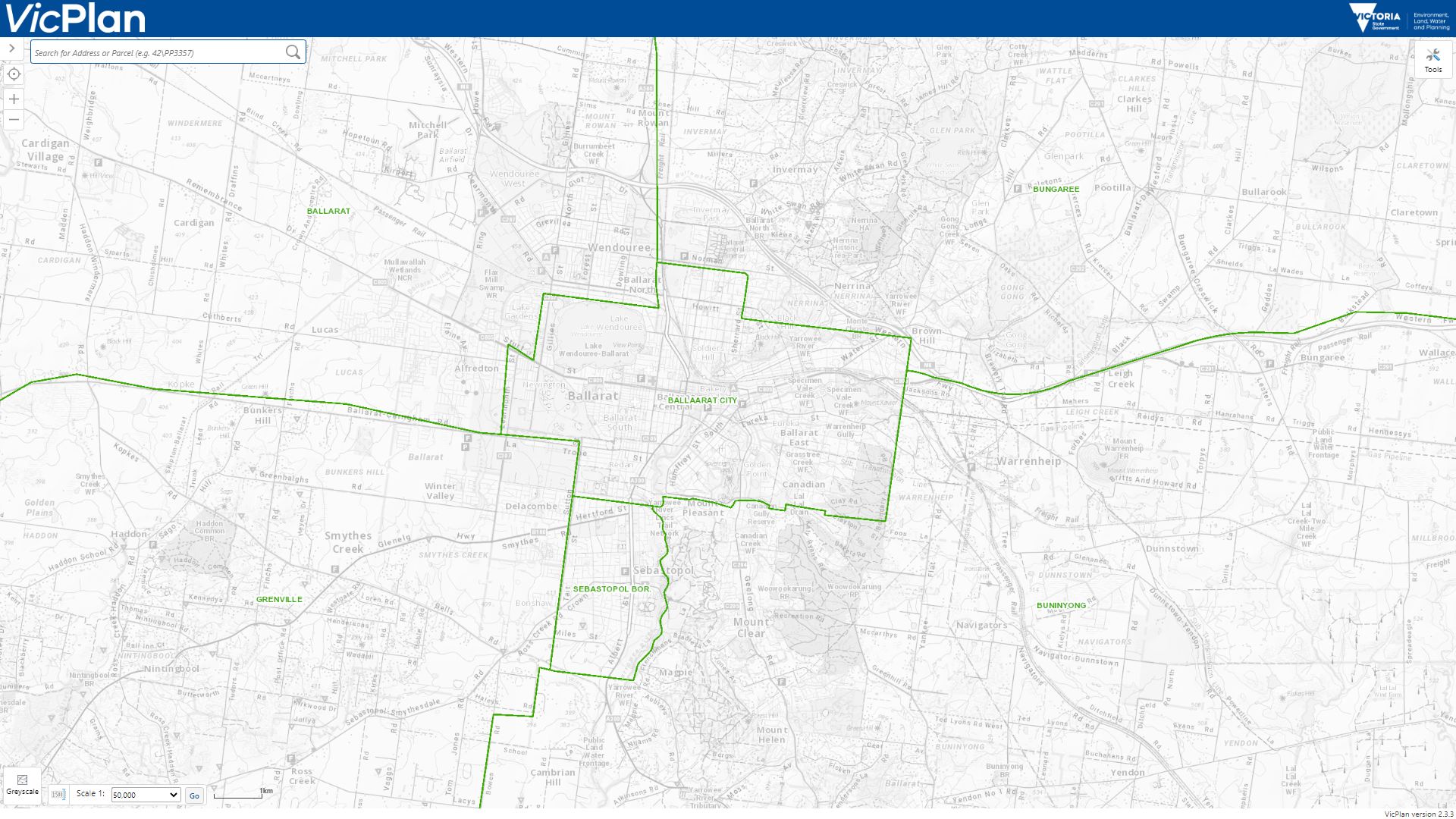
VicPlan map, Local Government Areas pre-1994 amalgamations layer
Today the City of Greater Bendigo, Bendigo was once governed by former City of Bendigo and Borough of Eaglehawk, with Shire of Strathfieldsaye, Shire of Huntly, Rural City of Marong and parts of the Shire of McIvor covering the outer areas.

VicPlan map, Local Government Areas pre-1994 amalgamations layer
Gippsland was a little different – what is now the City of Latrobe was split between the City of Moe and City of Traralgon which governed the cities of the same name, the City of Morwell governed both the city and surrounds, and the Shire of Traralgon, Shire of Narracan and Shire of Rosedale managed the rest.
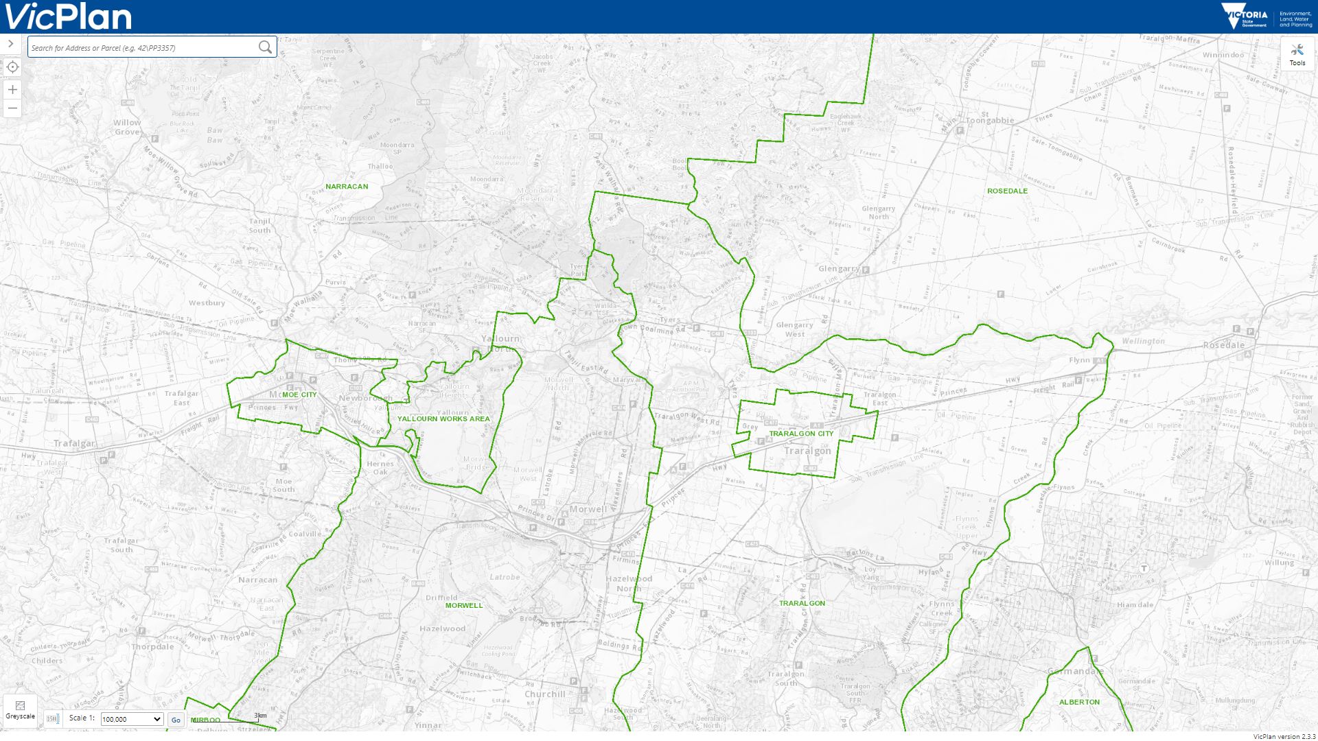
VicPlan map, Local Government Areas pre-1994 amalgamations layer
North East Victoria was another part of Victoria subject to “double barrelled” LGAs – both Benalla and Wangaratta had a City covering the urban area, and a Shire of the same name covering the surrounding districts.

VicPlan map, Local Government Areas pre-1994 amalgamations layer
Maryborough had some odd boundaries – they just drew a square on the map and called it the City of Maryborough.
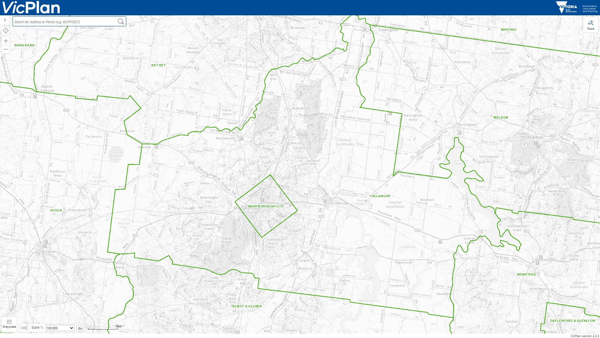
VicPlan map, Local Government Areas pre-1994 amalgamations layer
Castlemaine is another box drawn on the map, the City of Castlemaine having since been merged with the Shire of Maldon, Shire of Metcalfe and Shire of Newstead to form today’s Shire of Mount Alexander.
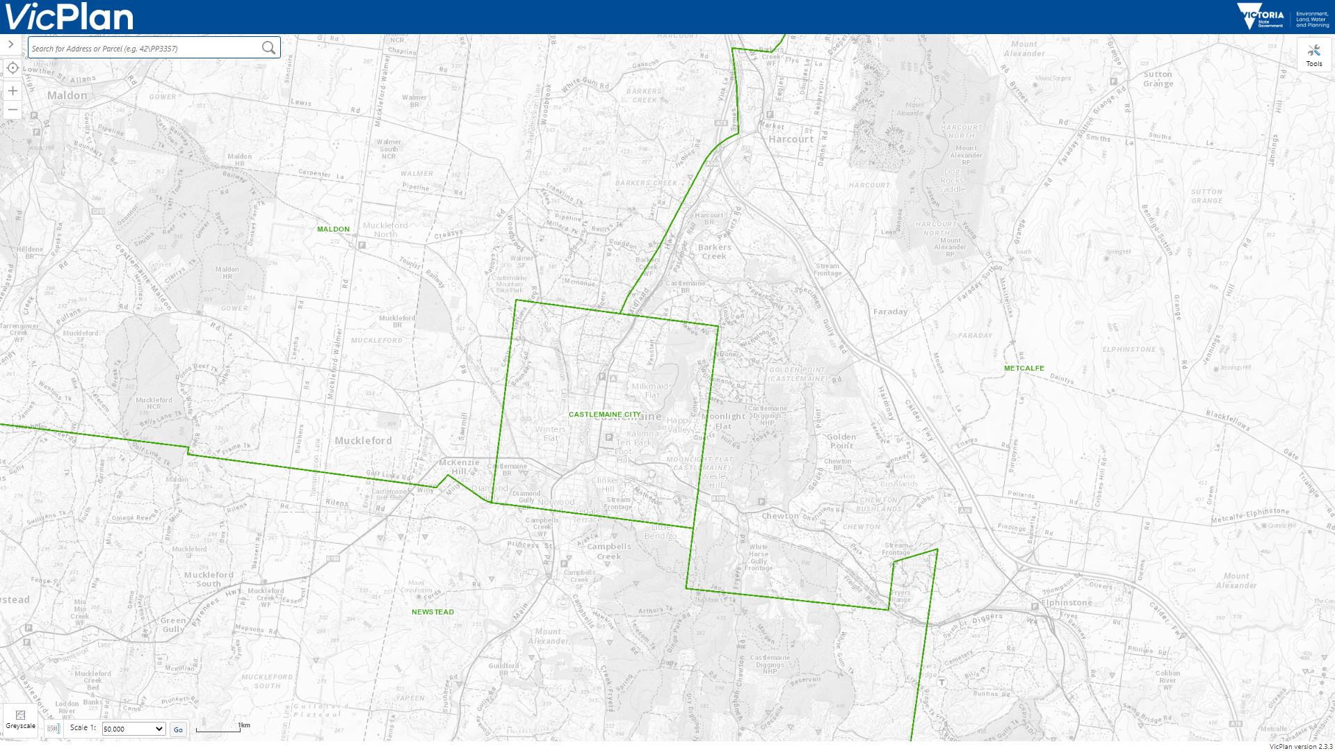
VicPlan map, Local Government Areas pre-1994 amalgamations layer
And finally, South West Victoria – Camperdown and Colac were their own little islands in the Town of Camperdown and City of Colac.

VicPlan map, Local Government Areas pre-1994 amalgamations layer
So how did they all come from anyway?
The short answer is “history” – for the rest I’ll just crib from the Wikipedia page on Local government in Victoria.
Local government had existed in Victoria since before its separation from New South Wales in 1851. The Town of Melbourne was established by an Act of the NSW Governor and Legislative Council in 1842 and the Borough of Geelong was established in 1849. Both bodies continued after the creation of Victoria as a separate colony, and both later became cities.
Road districts were established under legislation passed in 1853. From 1862 many road districts became shires pursuant to the District Councils Bill 1862. To become a shire, the road district had to be over 100 square miles (260 km²) in size and have annual rate revenue of over £1000. Promotion to town or city status was dependent on the gross revenue of the council.
The 1989 Local Government Act eliminated administrative distinctions between cities and shires, introduced the category of rural city and removed the possibility of declaring any further boroughs or towns. Five shires became rural cities.
An example of this evolutionary process is the local councils that once covered Geelong – established in the 1800s as either a “Road District” covering a small township or a “Borough” covering a young suburb, and growing in the years that followed to become a “Shire” or “City” respectively.
1849 – Geelong incorporated as a Town
1853 – Barrabool Road District proclaimed
1853 – Portarlington Road District proclaimed
1856 – Connewarre Road District proclaimed
1857 – South Barwon Municipal District proclaimed
1857 – South Barwon Road District proclaimed
1858 – Newtown and Chilwell Borough proclaimed
1860 – Portarlington Road District renamed as Indented Head Road District
1861 – Corio Road District proclaimed
1862 – Bannockburn Road District proclaimed
1863 – Meredith Road District proclaimed
1863 – Queenscliff and Point Lonsdale separated from Indented Head Road District to form Queenscliffe Municipal District.
1863 – South Barwon Borough created by amalgamating South Barwon Municipal District and South Barwon Road District
1864 – Bannockburn Road District redesignated as Shire
1864 – Corio Road District redesignated as Shire
1865 – Indented Head Road District redesignated and renamed as Bellarine Shire
1874 – South Barwon Shire created by amalgamating Connewarre Road District and South Barwon Borough
1875 – Geelong West Borough proclaimed
1910 – Geelong proclaimed a City
1915 – Meredith Shire added to Bannockburn Shire
1922 – Geelong West proclaimed a Town
1924 – Newtown and Chilwell proclaimed a Town
1929 – Geelong West proclaimed a City
1959 – Newtown and Chilwell proclaimed a City
1967 – Newtown and Chilwell City renamed as Newtown City
1963 – Queenscliffe Municipal District redesignated as Borough
1974 – South Barwon proclaimed a City
1989 – Bellarine proclaimed a Rural City
And where did they go?
Ian Tiley from the University of New England Centre for Local Government has the answer to this one, in his paper Evolution of Council Amalgamation in Victoria Tasmania and South Australia. The proliferation of local governments had been seen as a problem for some time.
Progressive investigations into local government reform have been undertaken since the 1960s, when Victorian local councils numbered 210. In 1962, a Commission of Inquiry into Victorian Local Government recommended reduction in the number of municipalities to 42, but the Inquiry was not acted on. A 1979 Report to government recommended establishment of a Municipal Commission to restructure local government. In 1985, the Victoria Grants Commission undertook a statistical analysis of economies of scale in local authorities of varying sizes and predicted a financial crisis in smaller units unless they were amalgamated.
The Cain Labor Government deciding to take action in 1985, but failing.
In September 1985, Victorian Premier Cain announced a strategy for state-wide amalgamations of local government. There was pressure for amalgamation in some economically-depressed, manufacturing reliant Victorian provincial cities, which had a relatively large number of local authorities in their urban areas, such as Geelong (four), Bendigo (five) and Ballarat (six) councils.
However, a year later, because of a combination of community opposition, bypassing of existing local government power structures, failure to establish majority support, conflicting aims, and lack of restriction in scope, the Premier announced that restructuring would only occur on a voluntary basis and attempts to reduce the 210 local authorities in Victoria at that time failed.
With the Kennett Liberal Government reopening the issue on winning government in 1992.
The local government reform implementation process took place in two stages. The first phase occurred during the initial Kennett Government term of office and entailed a radical agenda that fundamentally altered local government. The second reform phase from 1996 onwards consisted of consolidation of central direction of the local government sector through a variety of means including threats, contempt for some local government representatives and ad hoc interventions by the Minister.
The Kennett government quickly introduced the Local Government (General Amendment) Act 1993 to enable transformation of the Victorian municipal system. The Act established a Local Government Board to provide a process for reviewing local government structure and specifically precluded the Victorian Supreme Court from hearing any proceedings brought against the Board, its staff or the Minister in respect of such review.
The Board adopted a forceful “top-down” style (and community of interest was not considered a relevant issue, except where it could be used to suggest that existing local government boundaries divided communities as strong commercial area.
But merging local government areas wasn’t the only outcome of the Kennett-era reforms.
There were three key features of the municipal reforms.
Firstly, councils were summarily sacked in successive stages so that local government was effectively suspended and communities disenfranchised as Government-appointed commissioners assumed administrative responsibility under strict oversight of the Local Government Board.
The second feature was the ultimate reduction in the number of local government councils from 210 to 78 and allied reduction in staff numbers, buildings, plant and equipment, services and capital reserves.
The third key feature was that an increasing proportion of council budgets were required to be subject to Compulsory Competitive Tendering. The management tools of CCT and the consequent privatisation of services created a more “entrepreneurial” government and reduced the role and function of local government in favour of the private sector.
The hollowing out of local government capabilities following the introduction of Compulsory Competitive Tendering is still seen today.
Footnote 1 – the one that got away
There was one local government area that escaped the forced amalgamations of 1994 – the tiny Borough of Queenscliffe. Covering an area of just over 10 square kilometres and with a population of almost 3,000 people, it is the smallest local government area in Victoria.
https://commons.wikimedia.org/wiki/File:Queenscliffvic-airview-0508-2601-63.jpg
Labor Party MP for Geelong North stating at the time.
…we are not sure why it was omitted. The Minister for Local Government said it was because Queenscliffe is unique. The Premier said it was because of the council’s effectiveness. Some people suggest the uniqueness of Queenscliffe has a lot to do with the number of influential Liberal Party members living at Point Lonsdale who have exerted pressure
Footnote 2 – the mysterious Yallourn Works Area
Out in the Latrobe Valley west of the City of Moe was the mysterious Yallourn Works Area.
VicPlan map, Local Government Areas pre-1994 amalgamations layer
I knew Yallourn was a company town run by the State Electricity Commission of Victoria.

Which was eventually swallowed up by a coal mine.

But I didn’t realise Yallourn was also an unincorporated area subject to the almost total control of the SECV.
Yallourn was a company town, which meant that the State Electricity Commission was simultaneously landlord, employer and governor. The Commission decided who lived there, and exercised control over public and private space in the town.
The establishment of the Yallourn Town Advisory Council in 1947 curtailed the SEC’s autocratic administration of the town. But resident action groups were no match for the SEC or the Victorian Parliament once the decision was made in the 1960s to get rid of the town.
Footnote 3 – Kennett complains about ‘woke’ names
In 2021 the Moreland City Council was in the news for wanting to change its name due to links to slavery, and Jeff Kennett weighed in by saying that councillors who voted for the name change should pay the cost of the changeover. One small problem there Jeff – you created it back in 1994 when you amalgamated the former local government areas of the City of Brunswick, the City of Coburg and the southern part of the City of Broadmeadows. 🙄
Footnote 4 – PTV’s local area maps and local government areas
Public Transport Victoria doesn’t publish a full map showing all models of public transport in Melbourne – they stopped updating it back in 2009 – but does have a series of local area maps broken down by local government areas.

As someone who grew up in Geelong, it has taken me years to work out which local government areas cover which part of Melbourne, and I still don’t know the borders between most of them – just rough mappings to suburbs.
So perhaps I shouldn’t be so hard on the people I’ve met who didn’t know that Victorian towns outside of Melbourne are big enough to be divided up into named suburbs.
Further reading
- Evolution of Council Amalgamation in Victoria Tasmania and South Australia by Ian Tiley.
- Local Government Areas for Victoria prior to the 1994 amalgamations dataset at Data Vic.
- Controversial council amalgamations redesign Melbourne, The Age, 1994,
- State Electricity Commission (Yallourn Area) Act 1947
Plus the former local government areas in regional Victoria and metropolitan Melbourne are listed over at Wikipedia.

Dad was a senior council officer at the then City of Footscray during the Kennett amalgamations. One comment he made was that many existing local government authorities were far too small to provide the services that were expected from a modern LGA to their local communities – the Shire of Pyalong was one he highlighted.
The counter side of this was the loss of jobs and residents in the smaller rural shires when the local council was amalgamated. Even if the job was retained, it was often shifted into the rural centre. This drove a lot of the rural protests.
One effect you didn’t mention was the spill of senior staff, who all lost their jobs and had to reapply for equivalent roles in the new LGAs. Of course, there were far fewer senior roles available after the amalgamations (Dad was the only senior officer from Footscray that got a role at the replacement City of Maribrynong). This was a massive loss of corporate knowledge.
The core problem was that the LGA boundaries had essentially become stuck in the 1880s despite changing demographics. This caused a lot of problems in growing areas (e.g. Geelong, Ballarat, Bendigo, & fringe Melbourne), declining areas (e.g. Pyalong!) and in shopping centres (e.g. Camberwell shopping centre, I think, was owned by three councils).
It’s also worth noting that the state government had had a very long term policy of constraining the size and power of the Melbourne LGAs – particularly the City of Melbourne – to prevent setting up a rival power base.
(If you want original source material, have a look at the annual ‘Victorian Municipal Directory’, available on-line at SLV, which mentions the history of each LGA.)
Interestingly within 20 years of the amalgamations a new issue with LGA boundaries emerged – Caroline Springs was developed as part of the Shire of Melton, despite what was a green wedge separating it from the rest of the LGA, and the bulk of residents using services in the City of Brimbank.
I should also mention the other problem with redrawing LGA boundaries – the LGAs themselves.
I well remember Dad telling me about the battle over Southbank. South Melbourne had spent a decade developing and nuturing the redevelopment from factories to retail/offices. They saw it as a long term source of rate revenue for the City. Just as it was successful, the City of Melbourne stole it after convincing the State government that it naturally was part of the CBD and the whole area should be managed as one. South Melbourne was absolutely ropeable, but there was nothing they could do.
The boundary of the Melbourne City Council and Moonee Valley City Council through Kensington and North Melbourne is another one that has been debated for some time.
https://www.localgovernment.vic.gov.au/__data/assets/pdf_file/0029/164675/2007_LG_Kensington_Panel_-_Final_Report_-_10Dec07.pdf
Oh, and Yallourn.
Have a look at “Digging people up for coal” by Meredith Fletcher for a discussion of the relationship between the SEC and the people of Yallourn.
Like all company towns, if you lost your job (or even retired) you lost your house and had to move away from your community. This gave enormous social normative power to the SEC and its senior staff, and they used it. The SEC – and the local Superintendent – totally controlled every aspect of the town and didn’t give up any of their power without a fight. You lived in the house the SEC told you to and kept it up to SEC standards. You shopped in the SEC stores. You socialised according to your husband’s position in the SEC. The wives didn’t have jobs – the SEC wouldn’t employ them and there were no private employers. Things the SEC hierarchy approved of happened, those that weren’t didn’t. You kowtowed to the SEC hierarchy and fitted in.
Those that didn’t or couldn’t built houses at the satellite towns like Yallourn North.
And, at the end, the SEC destroyed the community without a thought or care.
The fact that the minuscule Borough of Queenscliff escaped the radical reforms of Jeff Kennett was never properly explained by the government. The claim that it was due to the council’s “effectiveness” was laughable, so it has has always been ascribed to lobbying by influential Liberal Party figures, many retired, who reside in the area.
One Liberal premier, Tom Holloway, is buried in the Queenscliff cemetery, along with six Baillieus.
And there are still parts of Victoria not part of Local Government Areas – French Island and the alpine resorts, home to almost 900 people, as well as Lady Julia Percy Island, Gabo Island and other uninhabited small islands off the coast of Wilson’s Promontory.
There are also the six alpine resorts which are managed by management boards instead of a LGA.
https://en.wikipedia.org/wiki/Local_government_in_Victoria#Unincorporated_areas
From a few years ago The Age article on 1990s council mergers
https://www.theage.com.au/national/kennetts-blitz-a-decade-on-20040425-gdxqdy.html
Cheers!
Another double-barrelled location was Swan Hill. Formerly the City of Swan Hill and Swan Hill Shire, now the Swan Hill Rural City. Which extends all the way to Robinvale, 130Km from Swan Hill. With a population over 3,000, Robinvale isn’t much smaller than Kerang, which is only 60Km from Swan Hill and the seat of the Shire of Gannawarra.
Thanks – I missed looking at at part of the state.
I was on Wikipedia, and this was pretty much the same with Mildura, which was a city (that was only Mildura) and the Shire of Mildura (which excluded Mildura). https://en.wikipedia.org/wiki/Shire_of_Mildura