Finding out the boundaries of a given suburb in Melbourne these days is pretty easy – just head over to the Register of Geographic Names (aka VICNAMES) and it’s all there laid out in front of you – so it might be hard to believe they once existed on “vibes”. This is the story of how they came to be officially defined.
How I ended up down this rabbit hole
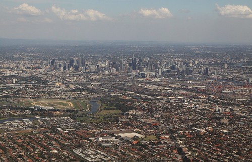
This story started when I was researching why so many places located in Sunshine West are called “Ardeer”.
Unfortunately the Register of Geographic Names doesn’t include the history of suburb boundaries, so I turned to a different resource – the Locality names and boundary maps found on the land.vic.gov.au website.
Of interest is the change register found at the bottom of each map, listing the issues of the Government Gazette in which boundary changes have been published in.

Unfortunately the earliest date on that map was September 1998. So how could I find an earlier set of suburb boundaries?
Enter the Geographic Place Names Act 1998
When I started researching how place names in Victoria are formalised, the “Geographic Place Names Act 1998” keeps on coming up. This act was assented to on 21 April 1998, with the new process for the registration of place names coming into operation from 31 December 1998.

So how was the introduction of the Geographic Place Names Act 1998 linked to the earliest suburb boundary maps that I had found?
Into the Hansard
The Hansard is the record of debates in the Parliament of Victoria, birthplace of laws, so I started digging around for references to the Geographic Place Names Bill.
And came across this speech from Marie Tehan, then-Minister for Conservation and Land Management, who described how geographic place names were managed in 1998.
Geographic place names serve two major purposes. The primary purpose is the practical need to identify localities and features and to communicate direction.
The administration of place names in Victoria up to the Second World War was carried out under various land acts. A comprehensive postwar mapping program identified the need to coordinate and standardise the drawing and publishing of official maps and plans and the naming of places.
The Survey Co-ordination (Place Names) Amendment Act passed in 1965 established the Place Names Committee to perform this role.
John Ross provided some further background on a 1995 review into the Place Names Committee.
The bill has been influenced by a detailed inquiry undertaken by KPMG entitled ‘Review of Place Names Committee — Final Report, November 1, 1995’.
Among other things the inquiry found that:
- persons who may make submissions or objections to the Victorian Place Names Committee are not defined;
- time lines are set for only one part of the process of consultation;
- ministerial involvement in the process is partial;
- the cover of the Place Names Committee is illogical — school names but not hospital names are controlled; and,
- some names go through the consultative process while others arrive via maps and are registered without consultation.
The inquiry also found that the processes of the Place Names Committee may duplicate processes of agencies that consult on name changes. One of the main conclusions of the inquiry was that the process may be very slow and duplicative.
Marie Tehan then described the new problem to be solved.
Three decades later significant changes in land information mapping and geographic place names have removed the need for a centralised assignment of names.
The state is mapped and the focus is now on meeting the needs of users of land information and organisations with a role in the naming of places.
Then went into the benefits reform would give.
Contemporary emergency service organisations using sophisticated communications technology now require real-time data which is accurate, up to date and more complete than ever before. Other community services and dispatch organisations are vitally interested in the clear definition of boundaries of places or localities for administration and planning purposes.
The state digital map base on which emergency service response is based is widely recognised as a stable and high quality database.
However there is a need for appropriate legislative authority to ensure that all current information relevant to the map base held by any public or private agency is provided as quickly as possible. In view of the unquestionable public benefit involved it is critical to ensure the prompt notification of changes, especially for such things as road and street names, new subdivisions and suburb boundaries.
But what came before?
The Survey Co-ordination Act 1958 defined a process in which place names were registered and new ones assigned, Australia Post had divided up the country into postcodes, and each postcode contained one or more localities – but the boundaries of these individual localities was left undefined by government.
It seems bizarre that there was a time that suburbs didn’t have boundaries, but in 1999 the Department of Infrastructure’s ‘Local Connections’ newsletter wrote.
For years, decades, and perhaps even centuries, the true name and boundary of Victoria’s suburbs has been a point of conjecture.
However, at last, through an extensive process of consultation and the community, an official set of suburb names and boundaries is available.
So how were these new boundaries defined?
Fixing it – the Geographic Place Names Bill
In February 1998 Marie Tehan introduced the proposed solution to all of the above problems – the Geographic Place Names Bill.
The bill defines ‘place’ as any place or building that can form part of administrative localities, landscape features and service infrastructure, and introduces three essential changes in the naming of places.
Firstly, the bill provides for guidelines which will allow local government authorities and other bodies to select and assign place names. These guidelines will be made by the Governor in Council and will provide a mechanism for a system of notification and central registration of new place names. This will ensure that all changes are notified to the state digital map base as quickly as possible.
Secondly, the bill provides for the establishment of a position of Registrar of Geographic Names with responsibility for policy development, collection and registration of approved names and management of the database of geographic place names.
Thirdly, the bill replaces the previous standing committee with an advisory panel with wide-ranging expertise to advise on the naming of places of special character. This is designed to ensure a more flexible process capable of providing the depth of technical knowledge and policy advice required on matters. Members of the panel will be drawn from the fields of mapping/geography; land information data management and service provision; local government; Aboriginal culture and language; orthography and linguistics; and, heritage and history.
The panel will be convened as required to comment and advise on the naming of places or features which cross local or regional boundaries, have special character or which have an affiliation for a wider group of Victorians.
These measures return control of place and feature naming to local communities and provide pro-active services to users and beneficiaries of the register of geographic places names. The reforms emphasise the role of local government authorities as critical providers of data. It is important that there is greater awareness of the significance of widely known current place names at the local level. This is the point at which additions to critical land information take place (including locality and feature names, street naming and addressing, and subdivision creation). The new procedures will significantly assist the regular updating of the register of geographic place names and the state digital map base.
Shadow minister for Environment, Conservation and Land Management Sherryl Garbutt then gave parliament a few examples of confusing place names.
Ms Garbutt — The process over the years since settlement has been haphazard and we now have confusion and duplication. I am told that there are 55 Stony Creeks in Victoria alone.
An honourable member interjected.
Ms Garbutt — Including one in Footscray. There is probably a Stony Creek for every honourable member. I do not know how many Railway Parades and Main Streets there would be scattered throughout the towns of Victoria.
Mrs Tehan — And High Streets.
Ms Garbutt — There would probably be a High Street in every town and suburb in the state. We are stuck with those sorts of situations, we have inherited that, but we have to map them and locate them extremely accurately these days.
And slipping in a dig at the way then-Premier Jeff Kennett went around changing names.
For example, when Premier changed the name of the National Tennis Centre in Flinders Park to Melbourne Park I suspect it was an attempt to put his stamp on the National Tennis Centre, which was built by the Cain government.
But with support from both sides of parliament, the Act assented to on 21 April 1998, with the new process for the registration of place names coming into operation from 31 December 1998.
So where to draw the line?
Community consultation on what the boundaries of Victorian suburbs should be commenced before the Geographic Place Names Bill was introduced to parliament, with The Age detailing the proposed changes in the City of Melbourne.
Committee redraws the city boundaries
Gabrielle Costa
The Age
19 May 1997Creating a new suburb called Docklands and extending the suburb of Melbourne to include Queen Victoria Market, Flagstaff Gardens and part of Prahran are among suggestions Melbourne City Council will hear tonight.
The place names committee, part of the Office of the Surveyor-General, has asked the council to review suburb names and boundaries in the municipality.
The council’s manager of strategic research, Mr Austin Ley, said proposals would be thoroughly debated and the public consulted before names were changed.
In a submission to the council’s planning committee tonight, Mr Ley will argue that while calling Southbank part of Melbourne would be logical, the area has developed its own character and a name change would meet “extensive community opposition”.
Decisions about redrawing boundaries would take account of community interest and the implications for businesses, some of which would, for example, need to change letterheads and advertising to reflect any change.
Among the changes that will be raised tonight are:
* Extending the suburb of Melbourne west to include Queen Victoria Market and Flagstaff Gardens.
* Creating a new suburb called Docklands in the area now controlled by the Docklands Authority.
* Changing Port Melbourne to Fishermans Bend from the centre of Boundary Street in the east to the West Gate Bridge.
* A small parcel of land in South Melbourne west of Clarendon Street would become part of Southbank.
* The area around Parliament and to Lansdowne Street would become Melbourne rather than East Melbourne.
* The part of Prahran between Commercial, Punt and St Kilda roads would become part of Melbourne.
* Melbourne University could become part of Carlton rather than Parkville.
After public consultations are over, the place names committee will again exhibit the council’s suggestions, including any modifications, for further consultation. A decision is expected by August.
Following it up with an opinion piece containing some light hearted suggestions.
Melbourne or Kennettville?
Steve Perkin
The Age
27 June 1997Jeff Kennett has asked all councils to review suburb names and boundaries as part of a drive to formally define suburbs for the emergency services and the Australian Bureau of Statistics.
Melbourne City Council has been accepting community suggestions for the past four weeks and submissions close today, although verbal submissions may be lodged on 4 July.
All councils have to lodge suggestions with the State Government by the end of July.
We’re planning to submit some. For example:
* The casino area could become Lloydworld or Xanadu.
* The Docklands could become Waverley and Waverley could revert to a swamp.
* Footscray could become Toxic Wastelands.
* Brighton could become Newman, because only Sam wants to live there since he shifted in.
* Parliament House could become Age City, just to really annoy Jeff.
* Melbourne could become New Orleans, because with Ragtime and Show Boat due here, we’re all going to feel like we live on the Mississippi.
And the result of the City of Melbourne’s consultation with the community.
Drover’s dog misses out as council rounds up names for new estate
Gabrielle Costa
The Age
7 Aug 1997The City of Melbourne’s planning, development and environment committee has considered several planned changes to suburban boundaries.
A proposal to change Melbourne University’s campus from Parkville to Carlton was dropped after the university and the Parkville Association approached a council committee.
Wesley College, with the support of Cr Malcolm Ritchie, asked that it not be included in Melbourne because its Prahran campus was internationally recognised as such. Kraft Foods asked that its Port Melbourne address not be changed to Fishermans Bend.
About 400 submissions were received on plans to draw parts of East Melbourne into Melbourne. Certain areas too small to be deemed suburbs but historically significant will be known as localities.
The council hopes to submit its changes to the place names committee by the end of the month.
The council’s manager of strategic research, Mr Austin Ley, said the changes were meant to clarify suburb names for the benefit of Australia Post and emergency services, but the council hoped “communities of interest” would also be embraced within any change.
Some small suburbs were worried they would be swallowed up by their bigger neighbours – Burnley and Richmond being one example.
Historic address could disappear; On the fringe a suburb is born, while another faces inner-city oblivion
Karen Lyon
The Age
18 April 1998Name changes could see Burnley become part of Richmond, and residents aren’t happy.
At the start of the century, Burnley was one of Melbourne’s oldest suburbs. By its conclusion its name could be consigned to the history books.
Burnley people have a great affinity with their suburb and its history. They recall a time locals would promenade up and down the Twickenham Gardens.
Those who didn’t feel like a stroll, could ride the ferris wheel or travel the Twickenham Ferry, which connected Burnley to affluent Toorak.
Now the people of Burnley drive through their suburb in cars or jump on a train. The pace of life has changed but there are remnants of the past: like a walk through the scenic gardens, where residents enjoy the environment and the calm.
But the Burnley thing to do may not remain under the name “Burnley,” which the suburb has had for so long.
Sure, they say, the Royal Burnley Golf course and the horticultural college will remain, and kids will still kick a ball at the Kevin Bartlett Reserve. But the suburb of Burnley, part of the better-known city of Richmond, may disappear.
The State Government’s place names committee wants to redefine suburban borders to help Australia Post, emergency services and the Bureau of Statistics.
Which means that for the sake of convenience, Burnley could become part of Richmond.
The recommendations committee has moved through the statutory process slower than expected, giving Burnley a reprieve. It had been hoped that recommendations and changes for the state would be in place by early this year but any decision – to be made by the City of Yarra – could be three months away. When the final decisions are made, the new suburban boundaries will have to be put in place by the State Government.
Not all Burnley residents are happy about the change. They like the feeling of a smaller community and the sense of history. Like Richmond, Burnley is one of Melbourne’s oldest suburbs.
Mr Ron Pinnell is a local whose thoughts are often found in the letters pages of newspapers. He is passionate about Burnley.
He thinks that Burnley is about to be lost and that nobody seems to care. There was a survey, he concedes, but “they didn’t talk to us and we will just disappear”. He believes the beauty of Burnley is that it is “low-scaled Richmond”.
“There are parks and wider streets. Residential areas without the industrial intrusion. It’s a more liveable part of Richmond.”
Others trying to become part of their prestigious neighbours, like the Ashburton residents trying to join Glen Iris.
Residents seek a new address
Sian Watkins
The Age
26 November 1998Hundreds of Ashburton residents are planning to change suburbs – without moving. They want the cachet of an address in neighboring Glen Iris, but without the price tag.
After the State Government’s place names committee recently approved an application by some residents to change four streets in Ashburton to Glen Iris, hundreds more residents have decided they want to live in Glen Iris, too.
Many residents from large areas to the north and south of the new addition to Glen Iris – which includes Highgate, Lexia, Ward and Dent Streets, off High Street – have asked Boroondara Council to survey the owners of about 1350 properties to see which suburb they would prefer to live in. Responses must be returned to the council by 11December.
The new Glen Iris residents sought the name change on the grounds that their area was once part of the Glen Iris Railway Junction Estate.
The council’s director of strategic management and support, Mr John Nevins, said yesterday that given that not all residents felt the need to change suburbs, a survey would be taken.
A clear majority would be required before the council approached the Place Names Committee seeking a name change.
Boroondara has dealt with these issues before. The Place Names Committee recently told the council it would agree to parts of Box Hill within Boroondara’s boundaries becoming Balwyn, and parts of Burwood becoming Glen Iris and Camberwell.
Some even sending a petition to Parliament, like the residents of an isolated pocket of Mulgrave who wanted to become part of the neighbouring suburb of Wheelers Hill.
Wheelers Hill boundary
Legislative Assembly Petitions
17 February 1998To the Honourable the Speaker and members of the Legislative Assembly in Parliament assembled:
The humble petition of the undersigned citizens of the state of Victoria sheweth information to be considered in the review of suburb names and boundaries by the State Government Place Names Committee.
Your petitioners therefore pray that the boundary of Wheelers Hill be extended to take in the area bounded by Lum Road, Wellington Road, South Eastern Freeway, Springvale Road and Ferntree Gully Road.
And your petitioners, as in duty bound, will ever pray.
By Mr E. R. Smith (2007 signatures)
With all of these requests being fed into the process that defined the new suburb boundaries.
And it’s official
It’s not real until it’s included in the Melway – so I dug through my collection of old street directories to see what I could find.
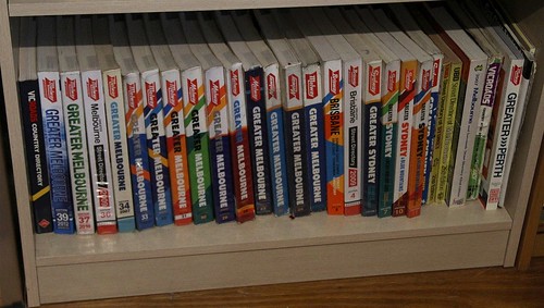
Landing on edition 26 and 27 – from 1999 and 2000 respectively.

As well as the big “ALL NEW SUBURB BOUNDARIES” on the front cover, Edition 27 from 2000 also included this note in the introduction section.

And a note to take a look at the map symbols on page 20 – where “Postcode Boundaries” sits alongside “Suburb Boundaries, Suburb Names, Postcode Numbers”.
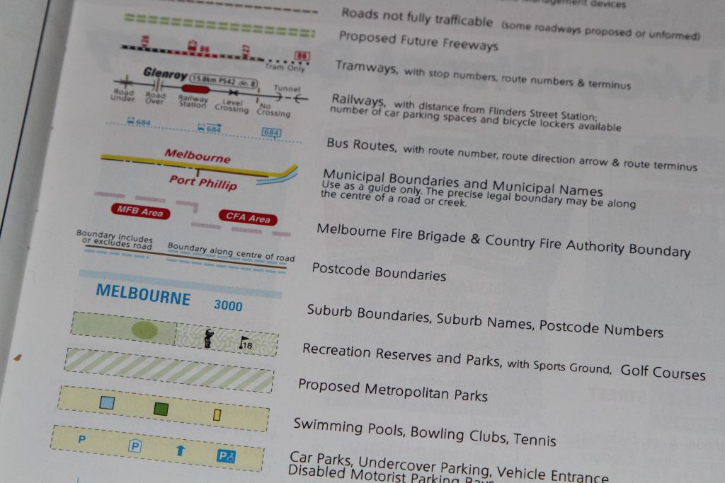
And then I took a look at the same page in Edition 26.

No “Suburb Boundaries” at all – just “Locality Names with Postcode Numbers”.
Footnote: 25 years on – did it work?
Despite the work done in 1998 to define suburb boundaries, the continuing expansion of Melbourne has seen the need for new suburbs to be defined. One example is the City of Melton, who gazetted 11 new ones in 2017 as empty paddocks became new dormitory communities.

But there are still some suburbs that are far too large, such as Truganina – stretching 15 kilometres across four distinct communities.

VicNames – The Register of Geographic Names
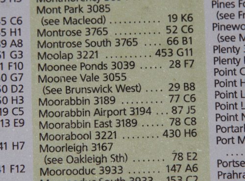
And the locality names wiped off the map following the formalisation of suburb boundaries never truly died – some like Moonee Vale still live on.
The Age covered the topic of Melbourne’s unbounded localities in a 2007 piece titled “secret suburbs“.
If you’re coming from Tally Ho you travel west – likewise from Bennettswood – and go via Willison, vaguely in the Macaulay or Batmans Hill direction. Pass through Rushall then Sumner and Anstey.
Westbreen is too far. Look just north of Moonee Vale and you’re there: Coonans Hill.
Directions from Burwood to Pascoe Vale South via Fitzroy have never sounded so confusing. But touring via Melbourne’s secret suburbs gives the route a quaint, village feel.
I’ve also got a few more “secret suburbs” to write about, but they’ll have to wait for another day.
Footnote: some gory legal details
The Victorian Registrar of Geographic Names maintaining the official Victorian Register of Geographic Names, supported by Geographic Names Victoria who administer the Geographic Place Names Act 1998. There is also a Geographic Place Names Advisory Panel, who provides expert advice to the Registrar on place naming policy, principles and naming issues.
The Victorian Registrar of Geographic Names is a member of the Permanent Committee on Place Names (PCPN) – a committee created from the various Australian and New Zealand committees on geographical names. The PCPN started in 1984 as the Committee for Geographical Names in Australia (CGNA) and it was renamed in 2005.

Great post. Growing up in Melbourne it brings back memories of localities that never officially existed as suburbs.
For example – I caught the train from Syndal station. Went to the Syndal shops and bought stamps from the Syndal Post Office. Went to Syndal Primary school and later St Christophers Syndal Catholic Primary. There were 2 other primary schools (Syndal North and Syndal South) and Syndal High School. Even Glendal primary school (an amalgamation of Glen Waverley and Syndal) was originally going to be called Syndal East. There were also three Syndal banks, the Syndal Credit Union, Syndal Baptist Church, etc, etc. However, Syndal as a suburb doesn’t actually exist – it is (was?) a locality shared by Glen Waverley and Mt Waverley straddling Blackburn Rd. It never had its own postcode and the boundaries were somewhat nebulous. I’m not sure it even officially exists as a locality anymore – even though many of the institutions mentioned above still exist.
Just north of Syndal is an even more secret suburb – The quaintly named Tally Ho. There is a Tally Ho tennis club, Tally Ho reserve and the small Tally Ho shops – but not much else.
VICNAMES lists Syndal as an “unbounded locality (neighbourhood)” with the centrepoint lying near the Syndal Tennis Club – so north of the railway station.
Don’t forget Syndal Technical School, which was located on Lawrence Road.
Great post! I now live in Seddon. I grew up in Melbourne (Chadstone, the housing commission part, near Jordanville!) and have just returned after 30 years away. Even family located around Ringwood have never heard of Seddon, and certainly I never knew of it until returning. One of those funny little suburbs.
Lisa
At least both Syndal and Seddon have railway stations of the same name, which raises their profile a little.
There was also the Tally Ho Boys Home, which was off Highbury Road down near Springvale Road. They also owned a few houses around the area where kids in State Care would live in foster care – one of these was next door to us where I grew up, just near the corner of Blackburn Road and Highbury Road – the Tally Ho shops were where as kids we went to the Milk Bar to buy our lollies! I also went to Syndal High in the early 80s before going on to Melbourne High (by train via Syndal Station).
I forgot about the Tally Ho Home – disappeared in the 1980s. I’m fairly sure Tally Ho got its name from the Tally Ho Hotel on the corner of Highbury Rd and Blackburn Rd. A Hungry Jacks is there now. The hotel was demolished way before my time and my memories of the area go back 50 years or so to when I was a young child.
Another locality in the area (south of Syndal) is Pinewood – named after an AV Jennings estate. There are a number of local places named after Pinewood (including a reasonably sized shopping centre) but I believe is not an official suburb.
BTW – had a look at the VICNAMES website – that is a rabbit hole you can go down and spend way too much time on.
I’ve got a copy of the 1990s book “Builders to the Nation: The A.V. Jennings Story” and it’s amazing how many Melbourne housing estates the company had their finger in.
[…] postcodes boundaries in place, and each postcode contained one or more localities, but before 1998 Melbourne suburbs lacked official boundaries – a situation rectified by the passing of the Geographic Place Names […]
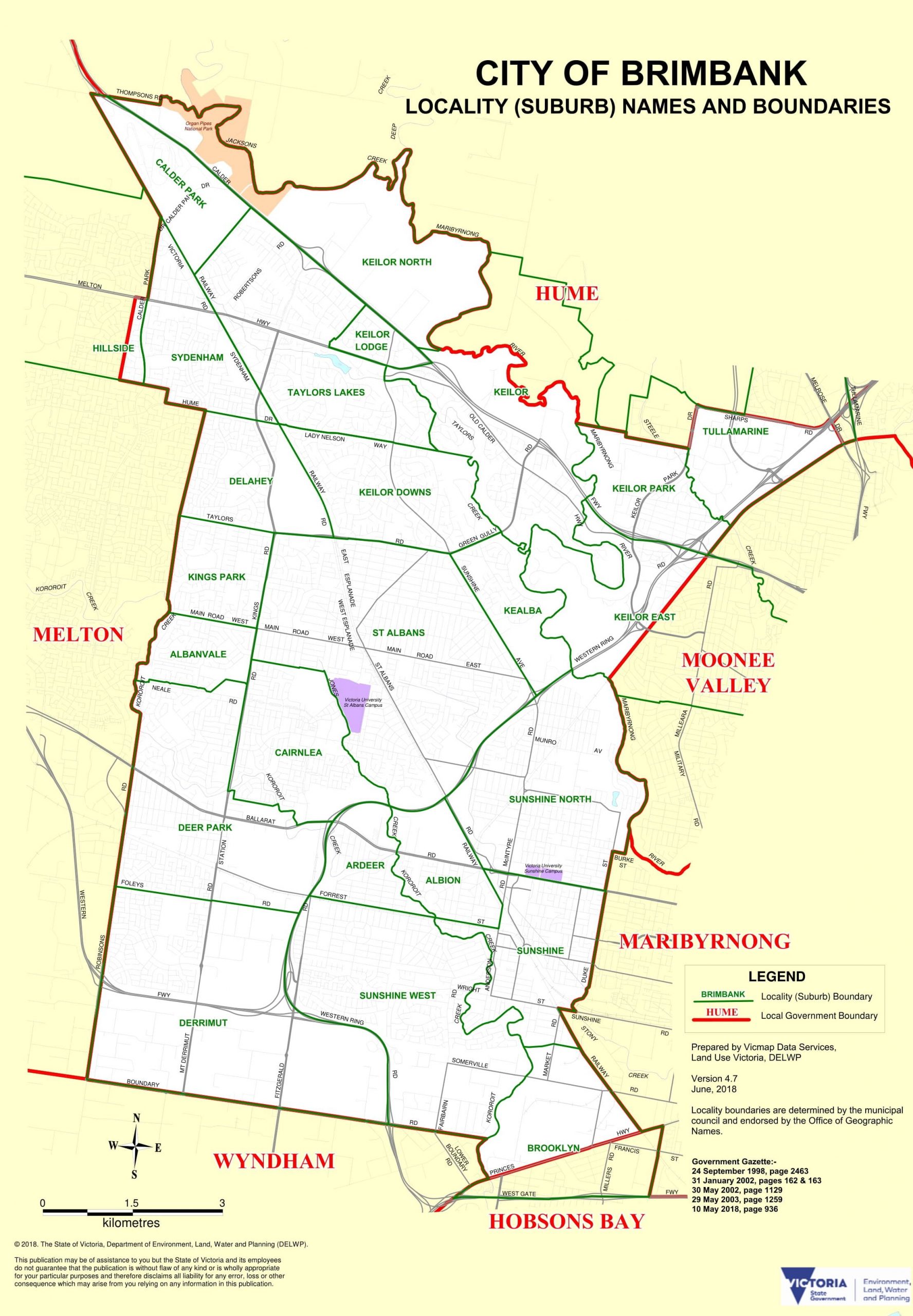
[…] my recent deep dive into how suburb boundaries came to be and the changing boundaries of the City of Brimbank, I found another curiosity – a house […]
[…] mentioned local lobbying in my original piece on suburb boundaries – residents wanted the cachet of an address in a fancy suburb, so they could profit from an […]