I’ve been writing a bit about suburbs in recent weeks, and here is the trigger for the whole rabbit hole – places called “Ardeer” that are located in the middle of Sunshine West.

The boundaries
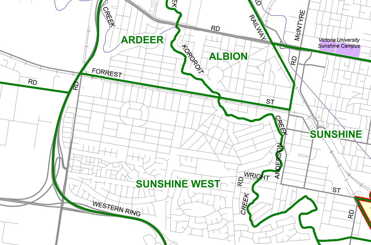
Enclaves are a territory that is entirely surrounded by the territory of another, but the border between Sunshine West and Ardeer is dead simple – north of Forrest Street and the railway line is Ardeer and postcode 3022, everything south is Sunshine West and postcode 3020.
And the “enclaves” of Ardeer
There is a Coles supermarket in Sunshine West, located on The Avenue.

But for some reason, Coles call it their “Ardeer” store.
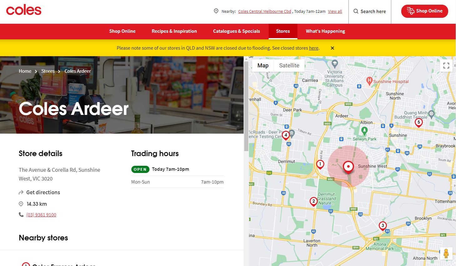
Down the road is a Coles Express service station, and Hungry Jacks restaurant.

Coles Express call it their “Ardeer” location, and gives the address as Ardeer 3022.

But Hungry Jacks calls their store “Ardeer” with a Sunshine West address, but a 3022 postcode.

Sunshine College had an “Ardeer” campus on Glengala Road, Sunshine West.

But gave their address as Ardeer, postcode 3022.

And finally, down the street is Ardeer South Primary School.

Who gives their address as Sunshine West, postcode 3020.

Clear as mud?
Time to do some digging
My first stop was the digital version of edition 1 circa 1966, and look at that – Ardeer continued south of the railway line into what is now Sunshine West, where every single one of the oddly named “Ardeer” locations I’d found are now located.

But when did the boundary change?
My next stop was the locality names and boundary maps maintained by the state government.
Of interest is the change register found at the bottom of each map, listing the issues of the Government Gazette in which boundary changes have been published in.

But after looking up each listed issue of the Government Gazette, I came up blank – none of the listed changes affected the boundary of Sunshine West and Ardeer.
My next step was to go digging through my collection of old street directories.
And after a whole lot of flicking around on maps 39 and 40, I landed on editions 26 and 27 – from 1999 and 2000 respectively.

Edition 26 from 1999 has Ardeer stretching south of the railway line into what is now Sunshine West.

The boundary of the two following on the high voltage transmission line easement.
Which was once reserved for a freeway.

Then jumping forward to edition 27 from 2000, the portion of Ardeer south of the railway was now Sunshine West.

Which reflects the current postcode boundaries.

Cartodraft Victoria & Melbourne Postcode Map
Postcode 3020 featuring the suburbs of Albion, Glengala, Sunshine, Sunshine North and Sunshine West.

And the far smaller postcode 3022 with Ardeer and Deer Park East.

And the answer
I’ve you’re a regular reader, then you might’ve already guessed the answer, but here goes – Australia Post has long had postcodes boundaries in place, and each postcode contained one or more localities, but before 1998 Melbourne suburbs lacked official boundaries – a situation rectified by the passing of the Geographic Place Names Act.
Community consultation on what the boundaries of Victorian suburbs should be commenced before the Geographic Place Names Bill was introduced to parliament, so in the case of Sunshine West a more logical boundary was created – the hard edge of the Melbourne-Ballarat railway line used to redefine the northern border, the Western Ring Road the western and southern borders, and the old postcode border along the transmission line easement fading away given the suburbs either side were tightly integrated.
Which left only one issue to resolve – the residents of the southern part of Ardeer now had an address in Sunshine West. In the 25 years since, as old residents move away and new ones move in, the new suburb name has taken root, but for institutions and national companies, renaming schools and stores has fallen by the wayside.
Footnote: postcode oddities
Melway edition 27 from 2000 has a strange feature – the boundary of postcodes 3020 and 3022 still followed the previous suburb boundary, leaving the suburb of Sunshine West split between two postcodes. By Melway edition 28 that oddity was gone, leaving the current postcode boundaries.
It’s hard to tell whether this was an error on the part of the Melway publishers, or a side effect of suburb boundaries and postcodes being managed by the State Government and Australia Post respectively, and the changes to the former not being immediately reflected by the latter.
Footnote: other boundary changes
For the benefit of future me, here are the five boundary changes made in the City of Brimbank as of 2022.
Government Gazette No. G38 Thursday 24 September 1998 page 2463.
City of Brimbank. Assignment of the 24 aforementioned suburb names and their boundaries within the municipality. The plan showing the suburb names and their boundaries may be inspected at the Municipal Offices, or the Office of the Place Names Committee.
Albanvale, Albion, Ardeer, Brooklyn,Calder Park, Deer Park, Delahey, Derrimut, Hillside, Kealba, Keilor, Keilor Downs, Keilor East, Keilor Lodge, Keilor North, Keilor Park, Kings Park, St. Albans, Sunshine, Sunshine North, Sunshine West, Sydenham, Taylors Lakes and Tullamarine.
Government Gazette No. G5 Thursday 31 January 2002 page 162 and 163.
Part of Delahey to Sydenham
As shown hatched on the map, south-west corner of Hume Drive and Sydenham Road.
Part of Taylors Lakes to Keilor
Bounded on the south side along Taylors Creek, from the previously gazetted boundary to Sunshine Avenue; on the west side from Taylors Creek along Sunshine Avenue to the on-ramp of the Calder Freeway; on the north side along the freeway on-ramp to the previously gazetted boundary.
Government Gazette No. G22 Thursday 30 May 2002 page 1129.
Parts of St Albans and Deer Park to Cairnlea
As set out on version 4.3 of the plan showing the suburb names and boundaries within the municipality.
Government Gazette No. G22 Thursday 29 May 2003 page 1259.
Part of Albanvale to Deer Park
As shown on version 4.5 of the plan showing the suburb names and boundaries within the municipality.
Government Gazette G19 Thursday 10 May 2018 page 936.
Part of Keilor to Taylors Lakes
The south-eastern corner of Taylors Lakes is being amended to incorporate properties within Kangaroo Paw Court, the boundary will run along the north-eastern boundary of PS731295. All other boundaries remain unchanged

Good article – I’d love to see a book on localities; how has who gets to name them and define their boundaries changed over time.
This supports my belief that the great suburb definition of 1998 was primarily about bureaucratic tidyness, and reflecting communities was way down the list (if on it at all). There are other examples. Most of the Gardenvale shopping centre, and the railway station, are in Brighton. The suburb is over the ‘natural’ boundary of the Nepean Hwy. Caulfield is even more entertaining. The Caulfield Racecourse, Caulfield railway station, Caulfield shopping centre (mostly), and the Caulfield campus of Monash University are actually in the tiny suburb of Caulfield East. The closest corner of the actual suburb of Caulfield is way over the other side of the racecourse, about 1.5 km by road from what you’d think of Caulfield.
Suburban railway stations are also entertaining. Much fun has been poked at Toorak for not being in the suburb (the suburb is over the adjacent High St). But there are others – Gardenvale and Caulfield obviously. Many other stations straddle a boundary (Ardeer & Richmond, for example) or are *just* inside a suburb (e.g. Malvern and Camberwell). Such stations are consequently nowhere near the centre of the suburb.
All this goes to show the tug-of-war between community notion of place, and that of the bureaucracy. Even, in fact, the different parts of the bureaucracy. The Lands Department had a strong early influence. But the influence ended at State boundaries, leaving single locations arbitrarily split (Albury/Wodonga; Wahgunyah/Corowa, Echuca/Moama). The railways had their own input naming stations that served locations, even if topographical drivers meant the stations were quite a distance from the locality notionally served. And then renaming them to serve their own notions of ‘neatness’ (e.g. Pyramid Hill to Pyramid, Glen Huntly to Glenhuntly). The Postmaster General had a big influence – particularly after Federation. The PMG had an absolute power of veto – refusing to countenance new locality names that might be confused by their sorters with existing localities, even in other states. Sorting offices would have had a strong influence on the notions of localities by dictating addresses. Postcodes (including the pre numeric ones) would have originally been based around sorting offices and their districts, with no strong drivers to match the borders with other boundaries. Local government also named areas which meant locality boundaries were often at arbitrary locations reflecting municipal boundaries (which, in turn, had a historical path dependency). I’m sure that’s how West Melbourne began, even though it is immediately adjacent to the North Melbourne shopping centre (and even includes part of it).
Incidentally, were you aware that one of the pre-Melways directories actually drew its maps based on *suburbs*?
My initial guess at “maps based on suburbs” was the Morgan’s Street Directory, but a check of the State Library of Victoria website shows it was the Collins’ Street Directories that did so.
http://handle.slv.vic.gov.au/10381/98883
The bureaucratic tidyness theory is an interesting one, and I didn’t realise the influence that the Postmaster General had. Many of the localities that still exist today seem to be tied to post offices, Geelong has a few that fall into this category, and I’ve written about the Moonee Vale post office before.
https://wongm.com/2015/03/where-is-melbourne-suburb-moonee-vale/
There was a clear boundary between Ardeer and Sunshine West before – the Transmission Line Reserve. There’s no need to redefine the boundary between the two.
My suspicion is that Brimbank council transferred the big part of Ardeer to Sunshine West to accommodate The Avenue estate. The Avenue was built around the time of the rezoning.
To make The Avenue Estate sound nearer to the CBD it was incorporated to Sunshine West. Sunshine West sounds more like Sunshine and Ardeer sounds like Deer Park. Deer Park then was the westernmost suburb of Melbourne. Beyond Deer Park was the Shire of Melton. All empty land. Caroline Springs and Burnsides don’t exist during that time.
So it’s all about marketing the new estate.
As for the “railway stations not in their suburb” this has sent me down another rabbit hole – were the stations located in their associated suburbs before the 1998 definition of their boundaries.
I have been on Route 420 a number of times and the bus passes the Ardeer Campus of Sunshine College on Glengala Road, and the buildings that you can see on Route 420 has been boarded up, so I think the campus has since closed.
Sunshine College closed the Ardeer campus at the end of 2020, students moving over to the upgraded Sunshine West site on Lachlan Road.
http://learningfromthepast.com.au/ardeer-high-school/
Since then the unused buildings have been set on fire multiple times – I think they’re up to their sixth arson attack now.
Ardeer station (technically in Sunshine West) does provide some community of interest for Ardeer south of the railway.
Can’t wait until you write about “Melbourne”. Like how you end up half way down St.Kilda Road past South Yarra, Southbank and be almost at St.Kilda (right on the edge of St.Kilda Junction) but there are still pockets and a strip called Melbourne to cover all of Queens Road and most of St.Kilda Road.
Yes, I live in St Kilda Road, Melbourne about two kilometres away from Flinders Street. Online it is now often referred to as St Kilda Road Central, Melbourne, and we do have a different post code, 3004.
Tram staff personal announcements confuse me when they say this tram, a 64 or 5 go to the end of St Kilda Road, while St Kilda Road continues on to Carlisle Street, being St Kilda Road, St Kilda.
Aside from the technical, there is suburbism to consider. An Ardeer address sounds better than Sunshine West.
I suspect that’s more of a “people don’t know where Ardeer is” case here – although it’s a nice little patch being nestled on the banks of Kororoit Creek with no through traffic.