The October 2022 Maribyrnong River flood in Melbourne’s west has reminded many that urban areas are not immune from being inundated with water. But what does this mean for the Metro Tunnel portal at South Kensington, located just a short distance from the river?

The flooding
The recent Maribyrnong River flood inundated the inner west.
Coming up beneath the railway line at South Kensington.
Maribyrnong River flooding viewed from the Sunbury line train. Kensington Rd under. Some buildings impacted. pic.twitter.com/MsQtTXLAvD
— Melbourne Way (@MelbourneWay) October 13, 2022
And putting Kensington Road underwater.

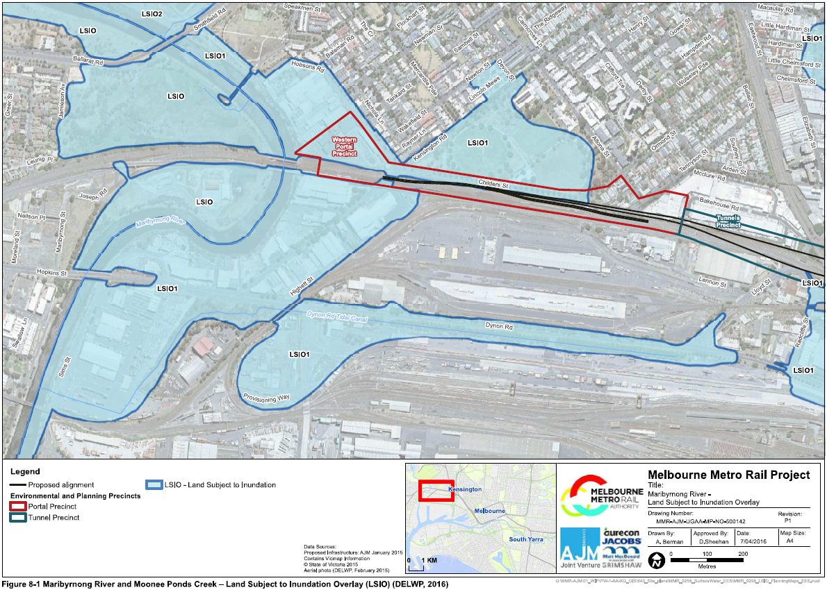
Which isn’t unexpected, given the entire area is covered by a ‘Land Subject to Inundation Overlay’.
As is the low lying land around Moonee Ponds Creek.

Enter the Metro Tunnel
The western portal to the Metro Tunnel is located beside South Kensington station, right in the middle of the floodplain.

So flooding was a consideration when designing the project, with the “Surface Water Impact Assessment” report dated April 2016 examined the risk of flooding to the tunnel, from four different sources.
- Maribyrnong River, which is approximately 500 m from the western portal
- Moonee Ponds Creek, which is approximately 100 m from Arden station
- Yarra River. This is approximately 120 m from CBD South station and could also potentially impact on the eastern portal at South Yarra
- City of Melbourne drainage systems along Swanston Street, adjacent to CBD South station.
The context of the Maribyrnong River at the tunnel portal.
The area immediately to the west of the western portal precinct is subject to flooding from the Maribyrnong River. The Maribyrnong River is one of metropolitan Melbourne’s most significant waterways. It’s catchment area upstream of the three parallel railway bridges to the west of the western portal is approximately 1,400 km2.
The three existing railway bridges through the rail embankment form a significant constriction to flood flows. The floodplain upstream of the bridges is relatively wide, and includes Flemington Racecourse on the east bank and parkland on the west bank. The floodplain upstream of the railway bridges is of the order of 800 m wide, yet the span of railway bridges is only of the order of 100 m. While there is a large bank of culverts through the embankment that forms the right (west) abutment for two of the bridges (the third – the Regional Rail Link Bridge – is a series of bridge spans), the only opening in the left abutment is along Kensington Road. The rail embankment is relatively high and would only be overtopped by an extreme flood event.
Flood gradients along the Maribyrnong River are relatively flat. Consequently, any flood level increases due to works in the floodplain are likely to propagate upstream for a significant distance.
Residential developments and associated compensatory mitigation works have been undertaken along the floodplain upstream of the rail bridges in recent decades. These include, for example, the Edgewater Development. This development included landfilling to enable residential development and excavation of the floodplain to provide compensatory flood conveyance.
Under existing conditions, a one per cent AEP flood would inundate Childers Street near JJ Holland Park to a depth of around a metre.
Looking into the probability flooding in these waterways would impact the tunnel.
Maribyrnong River:
The area around the existing rail embankment, in which the western portal (tunnel decline structure, and cut-and-cover section of tunnels) would be constructed, forms part of the Maribyrnong River floodplain. Under existing conditions, a one percent Annual Exceedance Probability (AEP) flood would inundate Childers Street near JJ Holland Park to a depth of around a metre. There is potential for Maribyrnong River floodwaters to fill the tunnels within hours during a flood event. Up to a days warning would typically be available in advance of such an event.
Moonee Ponds Creek:
The Arden station construction work site, and permanent entrances to Arden station, are in the Moonee Ponds Creek floodplain. The land around the station box and entrances is subject to flooding in events as frequent as 10 per cent AEP. Flood warning times in Moonee Ponds Creek are typically relatively short at only one to two hours.
Yarra River via City Loop:
The Melbourne Metro tunnels are potentially subject to flooding from the existing City Loop tunnels through the underground interconnection at CBD North station. Of the six City Loop tunnel portals in the area between Flinders Street and Richmond Stations, the portal on the line between Flinders Street and Parliament stations, near Federation Square, is at by far the greatest risk of riverine flooding, and is subject to flooding from the Yarra River in an event more frequent than a Year 2100 (ie including allowance for climate change impacts) one per cent AEP Yarra River flood. Up to three day’s warning would typically be available in advance of such an event. The Melbourne Metro tunnels could fill within hours once inundation thresholds were exceeded.
Yarra River via Eastern Portal:
In the absence of any additional mitigation works, the eastern portal would be subject to flooding from the Yarra River in an estimated Year 2100 0.1 per cent AEP (1,000 year ARI) event. A flood immunity risk assessment is required to determine whether this is acceptable.
Overland flows along Swanston Street:
The permanent entrances to CBD South station are subject to flooding from overland flows along Swanston and Flinders Streets. The Flinders Street Station entrance facing Swanston Street, in particular, is subject to some slight ponding of stormwater flows. Very little warning (tens of minutes) would typically be available in advance
of a major overland flow event at this site.
And detailed mitigations to prevent the Metro Tunnel from turning into a giant water slide for trains.
Maribyrnong River:
In the absence of any additional mitigation works, the permanent portal would be protected against flooding from the Maribyrnong River in an estimated one per cent AEP (100 year Average Recurrence Interval (ARI)) event, under Year 2100 conditions, with a 600 mm freeboard allowance. This would be provided by a proposed retaining wall on the north side of the rail embankment along Childers Street. It is proposed that automatic flood gates be installed during the project’s operational phase to protect the portal against flooding from more extreme events. These gates would extend to the full height and width of the portal and thus provide protection against even the most extreme flood event.
Moonee Ponds Creek:
The permanent station entrances in the Concept Design would be above 0.1 per cent AEP flood levels, including allowance for climate change impacts. The adequacy of this would need to be determined by flood immunity risk assessment.
Yarra River via City Loop:
Flooding from the existing City Loop tunnels through the underground interconnection at CBD North station could be mitigated by installation of flood gates on the City Loop tunnel portal near Federation Square to provide protection during both the construction and operational phases of the project. The other five portals in this area are all immune from flooding in a Year 2100 0.1 per cent AEP (1,000 year ARI) Yarra River flood event. A flood immunity risk assessment is required to determine whether this is acceptable.
Yarra River via Eastern Portal:
At a very minimum, it is recommended that a flood warning system be implemented, such that rail services could be suspended and the tunnels and stations evacuated in advance of an extreme flood. If the risk is not deemed to be acceptable, additional emergency management measures such as sandbagging or flood gates would need to be put in place to protect the tunnels from flooding in an extreme event during both the construction and operational phases of the project. It is currently proposed that the portal incorporate works to allow flood gates in the form of stop logs to be installed across the portal in advance of an extreme flood event. It is also proposed that stop logs be stored adjacent to the portal.
Overland flows along Swanston Street:
All entrances would need to be elevated slightly to provide an appropriate level of flood protection to be determined by flood immunity risk assessment.
A follow up report in August 2016 titled “Flood Defence Options at Tunnel Portals” looked deeper at the flood defence options, and included some additional options.
Eastern Portal:
The Surface Water Impact Assessment recommends that a flood warning system be implemented at this location. In my opinion it will be necessary, as part of the assessment of potential flood protection measures at this location, to also consider the installation of automatic flood gates as a response to extreme flood events. A flood warning system would continuously monitor precipitation and Yarra River water levels and, once predefined flood levels were reached, the system would issue a series of warnings to the operators (including operational and maintenance staff). Once the critical flood level was reached, the operational system would then close down the rail infrastructure (e.g. de-energise the OCL) and automatically close the flood gates.
Western Portal:
The Surface Water Impact Assessment recommends automatic flood gates be installed. Due to the relatively short advance warning times involved, an automated flood gate defence system that integrates an appropriate flood monitoring, warning and fault reporting system is recommended. Once the critical flood level was reached, the operational system would then close down the rail infrastructure (e.g. de-energise the OCL) and automatically close the flood gates.
Interconnection between the MURL and Metro Tunnel Rail Network:
The proposed interconnection between the MURL (Melbourne Central Station) and Metro Tunnel (CBD North Station) networks would provide pedestrian access between the underground station platforms, thereby providing an ingress for water to the Metro Tunnel. As with the Eastern and Western Portals, it is recommended that automated gates are installed at each MURL tunnel portal vulnerable to flooding during a ‘Probable Maximum Flood’ event. Alternatively, it is possible to install a flood gate in the connecting tunnels which would isolate the Metro Tunnel from any flood water in the MURL tunnels, should the MURL not have flood defences retro-fitted.
A final decision
December 2017 saw the flood mitigation scope set, following the signing of the “Metro Tunnel – Tunnel and Station PPP Project Agreement“.
5.2.7 Drainage and Flood Control
(e) The Tunnels, Stations and Portals must be protected from flooding through the most effective, practicable means. Active flood control may be required to prevent flooding into the Portals and some Stations. Passive means must be used where appropriate.
(f) Protection from surface water flooding must be provided as follows:
i. A freeboard that is 300mm above the 1:200 year Average Recurrence Interval (ARI) rainfall event level (plus provision for climate change) must be provided at all openings into the Tunnels and Stations to protect against surface water or other non-river flooding event.
ii. At the Portals, transverse drainage must be placed across the entrance to the Tunnels to capture the 1:200 year ARI flood event (plus climate change considerations for rainfall) in the decline structures and discharge the storm water in a controlled fashion to the local drainage system in accordance with the requirements of the statutory authorities.
(h) To protect against a river flooding event, a freeboard that is 600mm above the 1:1000 year ARI flood event level (plus provision for climate change considerations for rainfall and sea level rise) must be provided at all openings into the Tunnels and Station.
(i) Any flood waters from the Yarra and Maribyrnong Rivers must be prevented from entering the Portals. The design must:
i. determine appropriate warning systems;
ii. determine likely warning times;
iii. determine active responses which may include a manual or automatic responses; and
iv. consider the ease of tunnel closure in the case of a large flood event.
Works at the portals.
5.4 Portals
5.4.1 Project Co must:(f) design, supply and install active flood protection (1:1000 year event);
And requirements for specific locations.
5.8.1 Arden
(b) At Arden Station, to provide levels consistent with surrounding properties designed in accordance with the “Melbourne Water Guidelines for Development in Flood Prone Areas”, entrances and all openings must be as a minimum 600mm above the Moonee Ponds Creek 1:100 year ARI river flooding event level (plus provision for climate change).
5.8.2 CBD North
(c) Floodwaters from the Yarra River must be prevented from entering the CBD North Station via the connection to Melbourne Underground Rail Loop (MURL) at platform level.
(this change removed the need for changes to the City Loop to remove the flooding risk via that source)
It also required climate change to be taken into account.
15.4 Climate Resilience
15.4.1 The design must include measures for all high and extreme climate change risks to ensure the infrastructure, Stations and precincts are resilient to the projected impacts of a changing climate over the relevant asset’s Design Life. This should be in accordance with the adopted climate change projections and scenarios within the MMRA Climate Change Risk Assessment and Climate Change Adaptation Plan.
And another problem
The “Western Portal Development Plan” dated 2020 details the solution to another problem – how to prevent the emergency egress structure at South Kensington turning into a giant plughole leading into the tunnel.
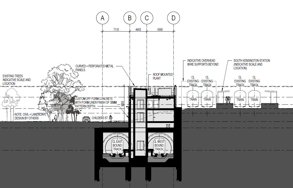
The building itself is large.
The functional requirements of the ancillary building, combined with required setbacks from existing infrastructure, largely dictate the form and scale of the building and demand a robust and enduring materiality. The building footprint is approximately 22 metres long, 12.5 metres wide and 9.1 metres high. This consists of two levels above ground facing Childers Street, and a basement below ground reaching the tunnels.
But is still in the middle of the floodplain.

But couldn’t be moved.
The above-ground building serves two core functions for the safe operation of the railway tunnels. Firstly, it contains spaces and equipment associated with safe emergency egress
of passengers from the tunnel, and secondly, having created an opening to below-ground infrastructure, the building is required to provide flood immunity through elevating all shaft and stair
openings above the predicted future flood levels.
As it needed an exit to ground level.

So the solution.
Flood immunity at the Western Portal is achieved by elevating all shaft and stair openings above the predicted future flood levels. The additional 3 metres in height (making up the total approximate 9.1 metre height of the ancillary building), is required to house a lift overrun and mechanical plant for the safe operation of the tunnel and emergency egress.
The ancillary building concrete treatment is reflective of the local context of the Western Portal and is required to provide water resistance. The proposed treatment of the upper section of the ancillary building, which is situated above the 1 in 1,000-year flood level, is perforated powder coated aluminium façade panels for screening the roof mounted plant.
Raising everything above flood level.

And building it
Walking past the Metro Tunnel portal at South Kensington, the tall concrete flood wall has been disguised by artwork.

But is clearly seen from inside the approach ramp.

The flood doors themselves to be installed at a later stage.

The lack of openings in the ventilation and emergency egress structure beside South Kensington station is also visible.

But the raised entrance at the future entrance to Arden station is still hidden behind the construction hoardings.

The flood doors in the link between State Library and Melbourne Central stations is also in the future.

But one completed aspect is the signal equipment room beside the railway at Hobsons Road, South Kensington.

Built atop an elevated steel deck.

Which has already kept it above the most recent floods.
Sources
- Melbourne Metro Rail Project Surface Water Impact Assessment (April 2016)
- Melbourne Metro Rail Project Flood Defence Options at Tunnel Portals (August 2016)
- Metro Tunnel Western Portal Development Plan (October 2020)
February 2023 update
The Age has published a piece Metro Tunnel among projects that may have exacerbated flood.
Footnote: examples elsewhere
In Hong Kong the Mass Transit Railway uses flood gates to protect the system from flooding via a damaged immersed tube tunnels.
Connections between stations and basements of neighbouring buildings are also protected by flood doors.

And station entrances are raised above street level to prevent localised flooding from entering stations.

So this 2016 report still assumed floodwater could flow over Flemington racecourse, after a wall was built in 2007 precisely to prevent that?
An interesting point – the diagrams showing the ‘Land Subject to Inundation Overlay’ include it because it’s a feature of the planning scheme, which presumably doesn’t assume the flood doors into the racecourse are always closed.
There was a story on A Current Affair about the wall that was built to protect Flemington Racecourse, while at the same time flooding nearby areas with no such protection (I personally find A Current Affair to be patronising to their viewers for cheap ratings and not normally watch it, but this was an important story in the light of what happened). Why protect a venue that only see major action a few times a year (and symbolises Australia’s gambling problems not to forget abuses of horses which has been highlighted a number of times on this very website) and not the residents who would be impacted? Because of what happened, I will be boycotting the Melbourne Cup coverage this year because Flemington Racecourse was protected from the floods (and let not forget that a lot of the connections are rich people).
And just remember that there are a lot of poor people in the area as well in suburbs like Maribyrnong and Footscray (you got public housing nearby in North Melbourne), so they sadly don’t have as much political clout as people in say Toorak or Camberwell.
And while many people blame councils (you can thank A Current Affair for it), the fact is that much of the problems could be attributed to the cuts to the State Emergency Services (Seven News interviewed someone in the area on the 4pm bulletin on Friday, who highlighted the dire straits that the local SES is in, like a lack of permanent building to host vehicles, as well as some vehicles being out of action), and it is the responsibility of state governments and not councils, as well as the increasing privatisation of services by governments (both Labor and Liberal, but mostly the latter).
It just came to me that while A Current Affair was on the attack on the retaining wall at Flemington Racecourse, it is expected that in a couple of weeks, when the Melbourne Cup is held at Flemington Racecourse, there will be coverage of things like Fashion on the Field and people enjoying themselves at the Melbourne Cup while at the same time ignoring the residents they claimed to have ‘fought’ for a couple of nights ago, as well as forgetting the floods.
I too picked up on the Flemington Racecourse flood plain, which is no more and it seems this was not taken into account in 2016. However, it does seem that flooding concerns are in order for the Metro and existing operational train tunnels.
A storm event flooded the New York City subway some years ago but maybe that wasn’t a one off. It was crippling for New York.
That was Hurricane Sandy in 2012 which caused $4.5 billion in damage – the MTA spent years afterwards addressing the vulnerabilities in the NYC Subway to hopefully avoid a reoccurrence.
https://www.progressiverailroading.com/passenger_rail/article/Hurricane-Sandy-Four-years-later-New-York-City-Transit-is-still-fixing-fortifying-the-rail-system–49988
[…] I wonder what difference these works made to the October 2022 Maribyrnong River flood? […]